
The Foss Dyke, or Fossdyke, connects the River Trent at Torksey to Lincoln, the county town of Lincolnshire, and may be the oldest canal in England that is still in use. It is usually thought to have been built around 120 AD by the Romans, but there is no consensus among authors. It was refurbished in 1121, during the reign of King Henry I, and responsibility for its maintenance was transferred to the city of Lincoln by King James I. Improvements made in 1671 included a navigable sluice or lock at Torksey, and warehousing and wharves were built at Brayford Pool in the centre of Lincoln.
Connection to the River Witham at Brayford was hampered by the small bore and depth of High Bridge, a medieval structure just below the pool. The channel through it was made deeper in 1795, but John Rennie's plans to demolish it in 1803 were not adopted. The canal was leased to several generations of the Ellison family, who profited from the tolls but failed to maintain it. Although cargos of coal and wool moved to the railway, the carriage of grain continued, and the last commercial operation was in 1972. The Brayford Mere Trust have turned Brayford Pool from a rubbish-filled eyesore into an attractive marina, and the Lincolnshire Waterways Partnership are opening a footpath and cycleway from Lincoln to Torksey; the section to Saxilby was officially opened on 26 July 2011.
The Foss Dyke was long thought to have been constructed by the Romans around 120 AD. Pointers include an inscribed statuette of the god Mars found in it at Torksey, which is now in the British Museum, but there is a lack of consensus among authors writing on the subject. The first record of it comes from Symeon of Durham, whose Historia Regium notes the following for the year 1121: "In the same year, king Henry cut a large canal from Torksey to Lincoln, and by causing the River Trent to flow into it, he made it navigable for vessels."
Some take this to mean that the canal did not exist before Henry's construction work. Thus Kevin Leahy writes: "Even if the Fossdyke had been built by the Romans it needs a high level of maintenance and after a few hundred years of neglect it would have been difficult to find, let alone navigate." Others, though, consider that Henry I merely scoured out an existing structure; Mark Bennett, writing for the East Midlands Archaeological Research Framework says: "The Foss Dyke is almost certainly Roman. No quay has been identified at Lincoln as yet although a length of wall suggestive of a quay was uncovered in the 1950s at the site of the Telephone Exchange east of the walled city and north of the Witham."
The canal is about 11 miles (18 km) long. It possibly follows an earlier line of the Trent, which emptied into the Wash in prehistoric times. Together with the 56 miles (90 km) of Car Dyke it formed part an important transport route from Peterborough to York.
It was reputedly used by the Danes when they invaded England and by the Normans to carry stone to build Lincoln Cathedral in the 11th century. Following King Henry I's work the canal deteriorated, until by the 17th century it was virtually impassable. Katherine Swynford, who lived in the area, is credited with having organized a protest to repair it, in 1375. King James I transferred ownership to the Corporation of Lincoln.
In 1671, during the reign of Charles II, Lincoln obtained an Act which authorised improvements from Boston to the Trent. Work was carried out on the Fossdyke, but only the first 100 yards (91 m) of the Witham, from Brayford Pool to High Bridge, received attention. The work was carried out by Samuel Fortrey, a man with previous experience of draining the fens. He was required to bear some of the cost himself, in exchange for some of the profits. The work was completed in 1672, and included a navigable sluice or lock at Torksey, which had first been proposed by Simon Hill in 1632.
Warehouses and wharves were built at Brayford Pool, but by 1717, passage from Torksey was again difficult. Coal traffic averaged 1,357 tons per year, bound for Lincoln, but tolls were insufficient to finance repairs. The city of Lincoln did not have the expertise to manage the waterway, and so leased it to Richard Ellison in 1741, who had experience with the River Don Navigation. He paid £75 per year for a navigation which generated around £100 in toll receipts. He dredged it to provide 3.5 feet (1.1 m) of depth, and re-opened it in 1744. Two years later, the tolls were £595, and continued to increase. Under his son, the tolls were £2,367 in 1789, while his grandson collected £5,159 in 1811.
Navigation through Lincoln and on to Boston was hampered by the shallow draught available under the medieval High Bridge, just below Brayford Pool. Sir Joseph Banks, when proposing the construction of the Horncastle Canal knew that the problem needed addressing, and William Jessop was commissioned to survey the Witham and the Fossdyke in 1791, with particular reference to the junction between the two. He proposed a bypass to the south of the city, using the Sincil Dyke, or excavating the channel beneath the bridge, although he recognized that this solution was not ideal, due to the narrow width of the bridge hole, and the lack of a towing path through it. However, the city was keen to keep trade within its limits, and improvements to High Bridge, which were completed by 1795, were authorised as part of the Horncastle Canal act of 1792.
The Witham Navigation was soon needing repairs, and the commissioners asked John Rennie for advice in 1802. His report, published in 1803, included recommendations to demolish High Bridge so that a waterway 34 feet (10 m) wide could be built under a new bridge, and improvements to the Fossdyke costing £12,260. Neither action was followed. The Fossdyke was difficult to maintain, because much of it ran through sand and quicksand. The situation was more complex, because it had been leased to the Ellisons for three generations, and Richard Ellison III was not keen to spend any money on it.
Income from tolls would have more than covered repairs, but there was little that could be done. A challenge to the legality of his lease was considered in the 1820s, but was not thought likely to succeed. He died in 1827, and Humphrey Sibthorp, his niece's husband, who was a proprietor on the River Witham, took over responsibility for it. He asked Isambard Brunel to survey it, and although he did so in 1833, no improvements were made.
Railways arrived in Lincoln in 1848. The Wakefield, Lincoln and Boston Railway had negotiated with the proprietors of the Witham and Fossdyke in 1846, to guarantee them an income by leasing the waterways. Richard Ellison IV had agreed a lease for 894 years, at £9,570 per year, based on the average profit for the previous three years plus 5 per cent. The line was built by the Great Northern Railway, who took over the leases already agreed. The Witham was affected more than the Fossdyke, as the line followed its bank from Lincoln to Boston. The Manchester, Sheffield and Lincolnshire Railway (MSLR) passed through Saxilby to Lincoln a little later.
Combined figures for the two waterways showed a drop in goods carried of two-thirds between 1848 and 1868. Cargos of coal and wool were the first to transfer to the railways. However, the MSLR, by then part of the Great Central Railway, built a dock and transhipment warehouse at Brayford in 1897. The Fossdyke carried 75,881 tons in 1905, and an average of 69,611 between 1913 and 1917, most of it general goods and agricultural produce. A series of takeovers and mergers resulted in its ownership changing several times, before it was nationalised, and became the responsibility of the British Waterways Board in 1948.
Although its date of construction is unknown, the London and North Eastern Railway Company built a small pumping station to the west of Torksey lock. It contained a steam-powered beam engine, which was probably made by Davy Brothers of Sheffield, and drove a double-acting bucket pump. It was situated close to the land drainage pumping station, which pumps into the tidal part of the Fossdyke, draining some 13,000 acres (5,300 ha) of low-lying land to the south of Torksey. Its job was to maintain the water levels in the navigation, but it was demolished in 1936, and no traces of it remain.
A new pumping station at a similar location was commissioned in 1974. This forms part of the Trent Witham Ancholme transfer scheme. A pumping station at Short Ferry on Barlings Eau pumps water through an 11-mile (18 km) pipeline to Toft Newton reservoir, on the upper reaches of the Ancholme. The water is used to maintain the flow and level of the Ancholme during the summer months and other dry periods. When there is insufficient water in Barlings Eau and the Witham, Torksey pumping station transfers water from the Trent through a short pipeline into Foss Dyke. From there it flows for 10.8 miles (17.4 km) along the waterway to Brayford Pool and so into the Witham, to supplement the water available for pumping.
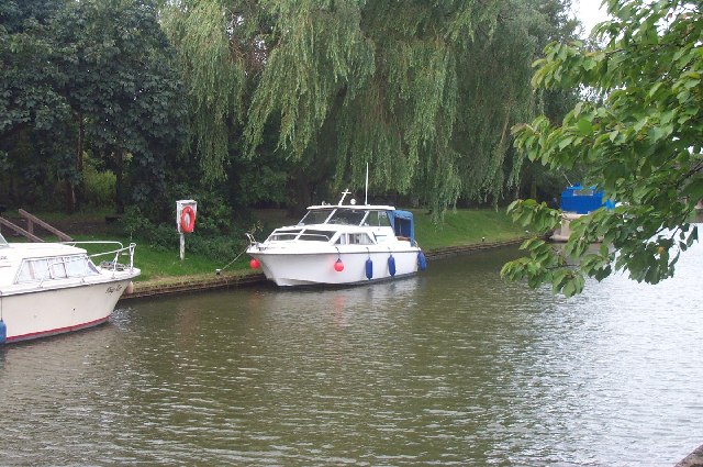
Unlike many waterways, the Fossdyke never closed, and continued to carry grain traffic until 1972. However, the demise of general commercial traffic had left Brayford Pool in the centre of Lincoln as a derelict eyesore, full of rubbish and sunken boats. The local Chamber of Commerce sought to address the issue in 1965, and formed Brayford Improvement Committee. Advice was sought from the Inland Waterways Association, and eventually the Brayford Mere Trust was constituted. They removed the wrecks from the pool, and have rebuilt the site, so that it offers facilities for visiting pleasure craft, now the major users of the waterway.
A former lift bridge, which crossed the western entrance to the pool, was replaced in August 1996 by a new concrete flyover, as part of the redevelopment of the south bank, which included the opening of the University in the same year.Two miles (3.2 km) to the west of Lincoln, a new 15-acre (6.1 ha) marina has been constructed at Burton Waters, as part of a 140-acre (57 ha) housing development.
Construction of a footpath and cycleway beside the canal from Lincoln to Saxilby has been carried out by the Lincolnshire Waterways Partnership, a joint initiative by Lincolnshire County Council, the Environment Agency and British Waterways. For much of its route it runs along the top of the northern floodbank, but drops down to a new crossing of the A57 road and a new bridge across the River Till near Saxilby. The route was officially opened on 26 July 2011. Extending the path to Torksey is a longer term aim.
* – Torksey – *
Torksey is a small village in the West Lindsey district of Lincolnshire, England. Foss Dyke, joins the River Trent by way of a series of lock-gates about half a mile (800 m) south of the village.
During the 9th Century, Torksey was part of the Anglo-Saxon Kingdom of Lindsey. In the late 860s, a Viking invasion force known to the English as the "Great Heathen Army" conquered eastern England. In 871–2, the Vikings established a winter camp in London, but returned to Northumbria soon afterwards, following a rebellion against their rule. During 872–3, the Great Heathen Army established its winter quarters at Torksey.
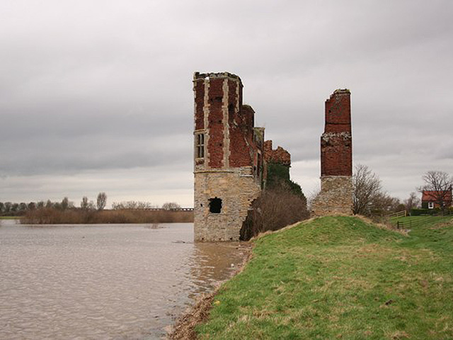
It is not known why Torksey Castle was built or why it was popularly termed a castle. The building was never used as a fortress and would not have been suitable for that purpose. A country house dating to the middle of the 16th century, it may have been built as a waypoint for the Jermyn family's travels to York or as a gift to one of their sons. In 1645, the property fell victim to the English Civil War. Having been taken from the Royalist Jermyn family by Parliamentarians, it was burned by Royalist soldiers based at Newark. Very little of the structure remained.
Though the Jermyn family retained control of the estate after the Civil War, the property was not restored, but continued to deteriorate. The remains of the buildings were scavenged for usable building supplies by residents of the area. Also, the hall was built quite close to the flood-prone River Trent, which may have stood the family in good stead as a source of transportation and commerce (as the Lords of Torksey had been permitted to levy tolls on the river's travellers), but which also contributed to the damage of the building through flooding. In 1961, the Trent River Board buried part of the ruins when raising the river bank. The English Heritage undertook the stabilisation of the building in the 1990s.
Torksey Viaduct has two 130 feet (40 m) spans across the River Trent. It was built between 1847 and 1849 to carry the Manchester, Sheffield and Lincolnshire Railway (Clarborough Junction-Sykes Junction branch). It is of unusual design and is regarded as the first box girder bridge. It was designed by John Fowler, who had been influenced by Fairbairn and Stephenson's tubular bridges at Conwy and the Menai Straits. The tubular girder bridge was not initially accepted by the Board of Trade's inspector Lintorn Simmons; this decision (and also the basic premise that a bridge designed by a member of the Institution of Civil Engineers which had passed all practical tests could be rejected by a railway inspector because he was uncomfortable with its novel design) was criticised by the ICE: "The subject has been discussed in the Institution of Civil Engineers, and every eminent engineer was of the opinion that the Government inspector was clearly wrong".
Threatened with a call for a parliamentary enquiry should approval continue to be withheld, the Railway Inspectorate reconsidered and approved the bridge un-modified. Subsequently, and consequently, the Board of Trade took the view that (as it explained in defending itself from criticism that the defects in the Tay Bridge should have been seen and acted upon by the Railway Inspectorate): "The duty of an inspecting officer, so far as regards design, is to see that the construction is not such as to transgress those rules and precautions which practice and experience have proved to be necessary for safety. If he were to go beyond this, or if he were to make himself responsible for every novel design, and if he were to attempt to introduce new rules and practices not accepted by the profession, he would be removing from the civil engineer, and taking upon himself a responsibility not committed to him by Parliament."
Torksey bridge was strengthened in 1897 by adding a more conventional central truss above the deck rather than by strengthening the box. The environmental charity Sustrans has carried out work on the viaduct in preparation for opening it as a walk/cycle-way. They obtained planning permission in 2015 for the paths, which Sustrans aims to link as a walking and cycling route to connect the quiet roads east of Torksey with those west of Cottam, a village about 1.2 miles (2 km) to the west.
* – Drinsey Nook – *
Drinsey Nook is a small village in the West Lindsey district of Lincolnshire, England. It is situated approximately 2 miles (3 km) south-west from Saxilby, close to the county border with Nottinghamshire. The village sits on the bank of the east of Lincoln section of the Foss Dyke, a canal which runs from the River Trent to the River Witham. The population of the village is included in the civil parish of Kettlethorpe.
Drinsey Nook is notable for Tom Otter, a man who murdered his new wife in 1805. Otter, reputedly from Treswell, was already married when he was made to marry his new wife, Mary, in a 'knobstick wedding'. He murdered her with a hedge-stake the same day, near the bridge that now bears his name. He was hanged in 1806, and was held in a Gibbet post adjacent to Gibbet Wood. Tom Otter Lane is the B1190 running south from the village, and Tom Otters Bridge is named after the site of the murder. For a more detailed and gory account from the local newspapers in 1850 please click here.


* – Saxilby – *
Saxilby is a large village in the West Lindsey district of Lincolnshire, England, about 6 miles (9.7 km) north-west from Lincoln, on the A57 road at the junction of the B1241. It is part of the civil parish of Saxilby and Ingleby, which includes the village of Ingleby. The village lies on the north bank of the Roman Fossdyke Navigation; there are remains of a Roman camp just outside the village.
The name is of Viking origin, Saksulfr+by, or "farmstead of a man called Saksulfr" and it appears as "Saxebi" in the Domesday Book (1086). In archived documents the village is often referred to as "Saxelby", with the current spelling of Saxilby only being found in common use from the late 19th century onwards.
Roman pottery has been found in digs in the area, which is what suggests they may have settled in this area. During the 9th century, Viking invaders took many areas of Lincolnshire and some settled in Saxilby. In the 12th century, the Normans began creating Manors and the Manor in the Saxilby area was given to Odo, the Bishop of Bayeux.
The village is well served with shops, pubs and restaurants and is comparatively easy to get to. Saxilby is situated next to the A57, which runs from Liverpool to Lincoln. The B1241 road runs through the village, called Mill Lane from the A57 junction until it meets Church Road where it becomes Sturton Road. Saxilby railway station, on the Doncaster to Lincoln Line, is situated close to the centre of the village, having originally been built by the Great Northern and Great Eastern Joint Railway.
Saxilby is served by a number of bus routes:

* – Brayford Pool – *
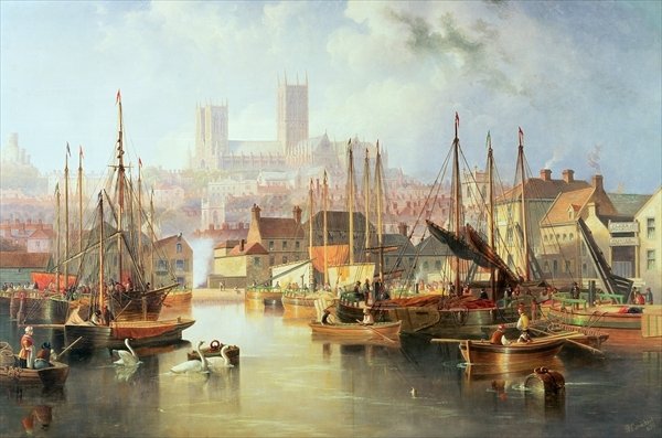
The Brayford Pool is a natural lake formed from a widening of the River Witham in the centre of the city of Lincoln in England. It was used as a port by the Romans - who connected it to the River Trent by constructing the Foss Dyke - and has a long industrial heritage. Today, the waterfront surrounding the pool is home to a range of hotels, restaurants, bars, entertainment venues and a modern University (University of Lincoln). There is also a year-long programme of events on the waterfront including vehicle displays, music evenings and carnival parades.
The Pool has been the focus of Lincoln's urban regeneration since the early 1990s. It is now overlooked by bars, restaurants, a cinema and, most significantly, the University of Lincoln. The only reminder of the past is the Royal William public house, a traditional pub housed inside a listed building. The Pool is used as a marina by houseboats and pleasure craft, as well as by anglers and kayakers. The Brayford Pool is known for its large population of mute swans (Cygnus olor). The swans made the news in 2004, over concerns about the animals' diet and overall health, as well as the appearance on the Pool of a number of Australian black swans (Cygnus atratus). Also located on the Brayford Pool is the Lincoln Unit of the Sea Cadet Corps - T.S. Wrangler. Brayford Island is in the Pool.
* – Visiting – *

Why not explore Lincoln’s waterways for yourself on the Water Rail Way, a purpose built foot and cycle path along the water, punctuated by local artwork. This 33 mile, mainly off-road cycle path follows the River Witham, joining Lincoln to the historic market town of Boston.
Mute swans are one of the UK's largest birds and they can grow up to about 1.5m high. Although by definition the mute swans are usually silent, they do make a loud hissing noise when they are angry and young swans make a high pitched whistling noise.
A number of mallard ducks can be found in the area as well as the less commonly known Muscovy ducks, native to Central and South America but brought to Europe by explorers in the 16th Century. The strange looking ducks have been immortalized to a degree with a ground floor suite named after them in the University’s Main Admin Building.
Brayford Pool is fully accessible. Assistance dogs are welcome. There are plenty of toilet facilities located in the vicinity. For a far fuller description of Lincoln accessibility please click here.
Location : Brayford Pool, Brayford Wharf N., Lincoln LN1 1YW
Transport: Lincoln (National Rail) then 6 minutes. Bus routes: 5, 47, 48, 49, 106, 107, 777, InterConnect 100 and SimpliBus 3 stop close by OR Tour bus.
Opening Times : Dawn till Dusk
Tickets : Free.
Tel: 01522 545458

