

Hadrian's Wall was begun in AD 122. A fort was built in stone at the Housesteads Roman Fort site around AD 124 overlying the original Broad Wall foundation and Turret 36B. The fort was repaired and rebuilt several times, its northern defences being particularly prone to collapse. A substantial civil settlement (vicus) existed to the south, outside the fort, and some of the stone foundations can still be seen, including "Murder House", where two skeletons were found beneath an apparently newly laid floor when excavated. In the 2nd century AD, the garrison consisted of an unknown double-sized auxiliary infantry cohort and a detachment of legionaries from Legio II Augusta. In the 3rd century, it comprised cohors I Tungrorum, augmented by the numerus Hnaudifridi and the cuneus Frisiorum. The Tungrians were still there in the 4th century, according to the Notitia Dignitatum. By 409 AD the Romans had withdrawn. Granary at Vercovicium. The pillars supported a raised floor to keep food dry and free from vermin. They are not part of a hypocaust. Most other early forts straddle the Wall and therefore protrude into barbarian territory. It is also unusual for Britain in that it has no running water supply and is dependent upon rainwater collection (for which purpose there is a series of large stone-lined tanks around the periphery of the defences). It also has one of the best-preserved stone latrines in Roman Britain (should one get caught short).
Housesteads is a former farm whose lands include the ruins of the fort. In 1604 Hugh Nixon, "Stealer of cattle and receiver of stolen goods" (now there is an interesting job title), became the tenant of Housesteads farm. From 1663, Housesteads was the home of the Armstrongs, a notorious family of Border Reivers. Nicholas Armstrong bought the farm in 1692, only to have to sell it again in 1694 to Thomas Gibson of Hexham for the sum of £485. They remained as tenants. They were a well-known band of horse thieves and cattle rustlers who used the old fort as a place to hold the stolen horses and cattle. They traded as far afield as Aberdeen and the south of England. At one time every male member of the family was said to have been a 'broken man', formally outlawed by English or Scottish authorities. Nicholas was hanged in 1704, and his brothers fled to America. The Armstrongs lived in a typical 16th century defensive bastle house of two storeys: the ground floor for livestock and the upper level for living quarters. Its ruins remain built up against the south gate of the Roman fort, with external stone steps and narrow loop windows. A corn drying kiln was inserted into the gate's guard chamber in the 17th century.
Today, you can wander the barrack blocks and the hospital. Peer into the oldest toilets you'll ever see, and admire the stunning panoramic views from this ancient fortress. The interactive museum showcases objects once belonging to Roman soldiers, and the mini-cinema will take you on a journey through time. Mobility parking available from National Trust Information Centre. Uneven paths and terrain on Hadrian's Wall, Housesteads Fort and Pennine Way. A cleared path is provided for the short walk from the visitor centre to the Wall and Fort. There are toilet facilities available (aside from the Roman latrines.
Location : Haydon Bridge, Hexham, Northumberland, NE47 6NN
Transport: Hexham (National Rail) then bus. Bus: Hadrian's Wall service, April to November daily.
Opening Times: Daily 10:00 to 18:00
Tickets: Adults £6.60 Concessions £6.00 Children £4.00
Tel: 01434 344363

Hadrian's Wall (Latin: Vallum Aelium), also called the Roman Wall, Picts' Wall, or Vallum Hadriani in Latin, was a defensive fortification in the Roman province of Britannia, begun in AD 122 in the reign of the emperor Hadrian. It ran from the banks of the River Tyne near the North Sea to the Solway Firth on the Irish Sea, and was the northern limit of the Roman Empire, immediately north of which were the lands of the northern Ancient Britons, including the Picts.
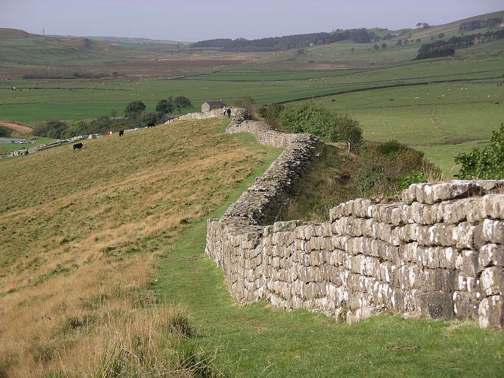
It had a stone base and a stone wall. There were milecastles with two turrets in between. There was a fort about every five Roman miles. From north to south, the wall comprised a ditch, wall, military way and vallum, another ditch with adjoining mounds. It is thought the milecastles were staffed with static garrisons, whereas the forts had fighting garrisons of infantry and cavalry.
In addition to the wall's defensive military role, its gates may have been customs posts. A significant portion of the wall still stands and can be followed on foot along the adjoining Hadrian's Wall Path. The largest Roman archaeological feature in Britain, it runs a total of 73 miles (117.5 kilometres) in northern England. Regarded as a British cultural icon, Hadrian's Wall is one of Britain's major ancient tourist attractions. It was designated as a UNESCO World Heritage Site in 1987. In comparison, the Antonine Wall, thought by some to be based on Hadrian's wall (the Gillam hypothesis), was not declared a World Heritage site until 2008.
It is a common misconception that Hadrian's Wall marks the boundary between England and Scotland. In fact Hadrian's Wall lies entirely within England and has never formed the Anglo-Scottish border. While it is less than 0.6 mi (1.0 km) south of the border with Scotland in the west at Bowness-on-Solway, in the east at Wallsend it is as much as 68 miles (109 km) away.
** – Size and Route – **
Hadrian's Wall was 80 Roman miles or 117.5 km (73.0 mi) long; its width and height varied according to the construction materials available nearby. East of the River Irthing, the wall was made from squared stone and measured 3 metres (10 feet) wide and 5 to 6 metres (16 to 20 feet) high, while west of the river the wall was originally made from turf and measured 6 metres (20 feet) wide and 3.5 metres (11 feet) high; it was later rebuilt in stone. These dimensions do not include the wall's ditches, berms and forts. The central section measured eight Roman feet wide (2.4 m, 7 feet 10 inches) on a 3 m (10 foot) base. Some parts of this section of the wall survive to a height of 3 m (10 feet).
Immediately south of the wall, a large ditch was dug, with adjoining parallel mounds, one on either side. This is known today as the Vallum, even though the word vallum in Latin is the origin of the English word wall, and does not refer to a ditch. In many places – for example Limestone Corner – the Vallum is better preserved than the wall, which has been robbed of much of its stone.
Hadrian's Wall extended west from Segedunum at Wallsend on the River Tyne, via Carlisle and Kirkandrews-on-Eden, to the shore of the Solway Firth, ending a short but unknown distance west of the village of Bowness-on-Solway. The A69 and B6318 roads follow the course of the wall from Newcastle upon Tyne to Carlisle, then along the northern coast of Cumbria (south shore of the Solway Firth).
Although the curtain wall ends near Bowness-on-Solway, this does not mark the end of the line of defensive structures. The system of milecastles and turrets is known to have continued along the Cumbria coast as far as Risehow, south of Maryport. For classification purposes, the milecastles west of Bowness-on-Solway are referred to as Milefortlets.
** – Purpose and Construction – **
Hadrian's Wall was probably planned before Hadrian's visit to Britain in 122. According to restored sandstone fragments found in Jarrow which date from 118 or 119, it was Hadrian's wish to keep "intact the empire", which had been imposed on him via "divine instruction". Although Hadrian's biographer wrote "[Hadrian] was the first to build a wall 80 miles long to separate the Romans from the barbarians", reasons for the construction of the wall vary, and no recording of an exact explanation survives.
Theories have been presented by historians, mostly of an expression of Roman power and Hadrian's policy of defence before expansion. On his accession to the throne in 117, there was unrest and rebellion in Roman Britain and from the peoples of various conquered lands across the Empire, including Egypt, Judea, Libya and Mauritania.
These troubles may have influenced Hadrian's plan to construct the wall as well as his construction of limites in other areas of the Empire, but to what extent is unknown. Scholars disagree over how much of a threat the inhabitants of northern Britain really presented and whether there was any economic advantage in defending and garrisoning a fixed line of defences like the Wall, rather than conquering and annexing what has become Northumberland and the Scottish Lowlands and defending the territory with a loose arrangement of forts.
The limites of Rome were never expected to stop tribes from migrating or armies from invading, and while a frontier protected by a palisade or stone wall would help curb cattle-raiders and the incursions of other small groups, the economic viability of constructing and keeping guarded a wall 72 miles (116 km) long along a sparsely populated border to stop small-scale raiding is dubious.
Another possible explanation for the wall is the degree of control it would have provided over immigration, smuggling and customs. Limites did not strictly mark the boundaries of the empire: Roman power and influence often extended beyond the walls. People within and beyond the limites travelled through it each day when conducting business, and organised check-points like those offered by Hadrian's Wall provided good opportunities for taxation. With watch towers only a short distance from gateways in the limites, patrolling legionaries could have kept track of entering and exiting natives and Roman citizens alike, charging customs dues and checking for smuggling.
Another theory is of a simpler variety — that Hadrian's Wall was partly constructed to reflect the power of Rome and was used as a political point by Hadrian. Once its construction was finished, it is thought to have been covered in plaster and then whitewashed: its shining surface reflected the sunlight and was visible for miles around.
Construction started in 122 and was largely completed in six years. Construction started in the east, between milecastles four and seven, and proceeded westwards, with soldiers from all three of the occupying Roman legions participating in the work. The route chosen largely paralleled the nearby Stanegate road to the south; the Stanegate predated Hadrian's Wall by about thirty years, and would have been a crucial supply route for its construction, as it seems that the Military Way connecting-road alongside Hadrian's Wall was not built until decades later.
The Stanegate ran from Luguvalium (Carlisle) to Coria (Corbridge), where there was a bridge over the River Tyne, and a junction with Dere Street which connected with the south. Along Stanegate were situated a series of forts, including Vindolanda, which could have offered protection and supplies during the building of the wall. To the north, the wall in its central and best-preserved section follows a hard, resistant igneous dolerite or diabase rock escarpment, known as the Whin Sill.
The initial plan called for a ditch and wall with 80 small gated milecastle fortlets, one placed every Roman mile, holding a few dozen troops each, and pairs of evenly-spaced intermediate turrets used for observation and signalling. However, very few milecastles are actually sited at exact Roman mile divisions: they can be up to 180 metres (200 yd) east or west because of landscape features or to improve signalling to the Stanegate forts to the south.
Local limestone was used in the construction, except for the section to the west of the River Irthing where turf was originally used instead, for unknown reasons; it was later rebuilt in stone. Milecastles in this area were also built from timber and earth rather than stone, but turrets were always made from stone. The Broad Wall was initially built with a clay-bonded rubble core and mortared dressed-rubble facing stones, but this seems to have made it vulnerable to collapse, and repair with a mortared core was sometimes necessary.
The milecastles and turrets were of three different designs, depending on which Roman legion built them – inscriptions of the II Augusta, VI Victrix, and XX Valeria Legions show that all were involved in the construction. The turrets were about 493 metres (539 yards) apart and measured 14.02 m2 (150.9 sq ft) internally. Construction was divided into lengths of about 8 kilometres (5 mi). One group of each legion would excavate the foundations and build the milecastles and turrets, and then other cohorts would follow with the wall construction. The wall was finished in 128.
** – Garrison – **
According to Sheppard Frere, the garrison reflected the political rather than military purpose of the wall. The wall provided the soldiers with an elevated platform from which they could safely observe movement of the local population. It had "heavy provision of cavalry" which could sally out from any of the milestone gates though as mentioned earlier, the garrison was neither expected nor trained to the level necessary to defend a city wall. Overall the fortifications appear to have required additional strengthening after the initial design and were stronger than their equivalent in Germany, probably reflecting local resentment.
Frere believes that the milecastles, which would have needed 1,000 to 1,500 men, were held by a patrolling garrison of numeri, though he concedes that there are no inscriptions referring to numeri in Britain at the time. Command headquarters was at Uxelodunum (nowadays called Stanwix) near Carlisle, where the Ala Gallorum Petriana was based. A signalling system allowed communication in minutes between Stanwix and York.
Further information on the garrisoning of the wall has been provided by the discovery of the Vindolanda tablets, such as the record of an inspection on 18 May of a year 92 and 97, where only 456 of the full quota of 756 Belgae troops were present, the rest being sick or otherwise absent.
** – After Hadrian – **
In the years after Hadrian's death in 138, the new emperor, Antoninus Pius, left the wall occupied in a support role, essentially abandoning it. He began building a new wall called the Antonine Wall about 160 kilometres (100 mi) north, across the isthmus running west-south-west to east-north-east. This turf wall ran 40 Roman miles, or about 60.8 km (37.8 mi), and had significantly more forts than Hadrian's Wall. This area later became known as the Scottish Lowlands, sometimes referred to as the Central Belt or Central Lowlands.
Antoninus was unable to conquer the northern tribes, so when Marcus Aurelius became emperor, he abandoned the Antonine Wall and reoccupied Hadrian's Wall as the main defensive barrier in 164. In 208–211, the Emperor Septimius Severus again tried to conquer Caledonia and temporarily reoccupied the Antonine Wall. The campaign ended inconclusively and the Romans eventually withdrew to Hadrian's Wall.
The early historian Bede (AD 672/3-735), following Gildas, wrote (circa AD 730):
Bede obviously identified Gildas's stone wall as Hadrian's Wall (actually built in the 120s) and he would appear to have believed that the ditch-and-mound barrier known as the Vallum (just to the south of and contemporary with, Hadrian's Wall) was the rampart constructed by Severus. Many centuries would pass before just who built what became apparent.
In the same passage, Bede describes Hadrian's Wall as follows: "It is eight feet in breadth, and twelve in height; and, as can be clearly seen to this day, ran straight from east to west." Bede by his own account lived his whole life at Jarrow, just across the River Tyne from the eastern end of the Wall at Wallsend, so as he indicates, he would have been very familiar with the Wall. What he does not say is whether there was a walkway along the top of the wall. It might be thought likely that there was, but if so it no longer exists.
In the late 4th century, barbarian invasions, economic decline and military coups loosened the Empire's hold on Britain. By 410, the estimated end of Roman rule in Britain, the Roman administration and its legions were gone and Britain was left to look to its own defences and government. Archaeologists have revealed that some parts of the wall remained occupied well into the 5th century. It has been suggested that some forts continued to be garrisoned by local Britons under the control of a Coel Hen figure and former dux.
Hadrian's Wall fell into ruin and over the centuries the stone was reused in other local buildings. Enough survived in the 7th century for spolia from Hadrian's Wall to find its way into the construction of St Paul's Church in Monkwearmouth-Jarrow Abbey, where Bede was a monk. It was presumably incorporated before the setting of the church's dedication stone, still to be seen in the church, precisely dated to 23rd April 685.
The wall fascinated John Speed, who published a set of maps of England and Wales by county at the start of the 17th century. He described it as "the Picts Wall". A map of Newecastle (sic), drawn in 1610 by William Matthew, described it as "Severus' Wall", mistakenly giving it the name ascribed by Bede to the Vallum. The maps for Cumberland and Northumberland not only show the wall as a major feature, but are ornamented with drawings of Roman finds, together with, in the case of the Cumberland map, a cartouche in which he sets out a description of the wall itself.
Much of the wall has now disappeared. Long sections of it were used for roadbuilding in the 18th century, especially by General Wade to build a military road (most of which lies beneath the present day B6318 "Military Road") to move troops to crush the Jacobite insurrection.
The preservation of much of what remains can be credited to John Clayton. He trained as a lawyer and became town clerk of Newcastle in the 1830s. He became enthusiastic about preserving the wall after a visit to Chesters. To prevent farmers taking stones from the wall, he began buying some of the land on which the wall stood. In 1834, he started purchasing property around Steel Rigg near Crag Lough. Eventually, he controlled land from Brunton to Cawfields. This stretch included the sites of Chesters, Carrawburgh, Housesteads, and Vindolanda. Clayton carried out excavation at the fort at Cilurnum and at Housesteads, and he excavated some milecastles.
Clayton managed the farms he had acquired and succeeded in improving both the land and the livestock. His successful management produced a cash-flow, which could be invested in future restoration work. Workmen were employed to restore sections of the wall, generally up to a height of seven courses. The best example of the Clayton Wall is at Housesteads. After Clayton's death, the estate passed to relatives and was soon lost at gambling. Eventually, the National Trust began acquiring the land on which the wall stands. At Wallington Hall, near Morpeth, there is a painting by William Bell Scott, which shows a centurion supervising the building of the wall. The centurion has been given the face of John Clayton.

** – Visiting – **
Take yourself out for an adventure and explore this World Heritage Site by experiencing a walking trail. Some of them are circular walks around Hadrian's Wall, others venture further afield. Voted number 18 on ITV's Britain's Favourite Walks 2018, if you'd like to have a go at the two walks that were mentioned, try the Sycamore Gap walk and Housesteads to Steel Rigg circular walk.
** – Sycamore Gap walk – **
A circular walk starting from the visitor centre to the Roman Fort and then along the World Heritage Roman wall footpath to the iconic Sycamore Gap. Enjoy magnificent views of Hadrian's Wall and the Roman Military Way. Explore natural wilderness and become immersed in the history as you return via the Roman Military Way. Each step includes Waypoints.
Classified as Moderate this walk is 5.2 miles long and should take approximately 3 hours.
Start: Housesteads Visitor Centre.
** – Housesteads to Steel Rigg circular walk – **
Explore Hadrian's Wall Country on this 8-mile circular walk starting at Housesteads Fort, one of the richest parts of the country for Roman archaeology. Head west along the Wall built in AD122 before returning north of the Wall to appreciate the stunning surroundings and impressive Whin Sill the Wall was built on.
Classified as Moderate this walk is 8 miles long and should take approximately 3 to 4 hours.
Start: Housesteads Visitor Centre.
** – Facilities – **
General:-
Family:-
Access:-
Location : Near Bardon Mill, Hexham, Northumberland, NE47 6NN
Transport: Hexham or Haltwhistle connect with bus (Please ensure the bus is running during the time you are wishing to visit). Bus: Hadrian's Wall service (AD122) runs from Saturday 24 May 2014 daily until Sunday 31 August 2014, Newcastle train station to Hexham train station to Carlisle (passing Haltwhistle train station).
Opening Times Fort: Daily 10:00 to 18:00
Opening Times Wall: All day, everyday.
Tickets Fort: Adults £6.60 Concessions £6.00 Children £4.00
Tickets Hadrians Wall: Free
Tel: 01434 344525
