
Aira Force is a waterfall in the English Lake District, in the civil parish of Matterdale and the county of Cumbria. The stream which flows over the waterfall is Aira Beck, which rises on the upper slopes of Stybarrow Dodd at a height of 720 metres (2,362 feet) and flows north-easterly before turning south, blocked by the high heather-covered slopes of Gowbarrow Fell. It turns south on its eight-kilometre journey to join Ullswater, at a height of 150 metres (492 feet). One kilometre before entering the lake, the beck makes the 20 metres (66 feet) leap down a rocky and steep sided ravine at the falls known as Aira Force. The water falls approximately 22 metres (72 feet) to a rocky pool, from where the beck continues through a shallow valley to the lake.
The river name Aira is derived from Old Norse eyrr, a gravel bank, and Old Norse á, a river, hence The river at the gravel bank, a reference to Aira Point, a gravelly spit where the river enters Ullswater. The Old Norse word fors, waterfall, has been adopted into several northern English dialects and is widely used for waterfalls, with the English spelling 'Force'. Thus, The waterfall on gravel-bank river.
A small arched bridge spans the stream just as the beck goes over the falls giving a spectacular view from the top as the water makes its leap. There is also a second bridge at the foot of the falls. Both bridges were constructed in honour of two members of the Spring family early in the 20th Century. Cecil Spring Rice was the British ambassador to the USA during the First World War, while Stephen Spring Rice was a senior civil servant. The bridges are of particular interest: the lower is made of vertical stones, not traditional in this area of Cumbria, while the higher has horizontal stones, more in keeping with the dale customs.
The Lake Poet William Wordsworth paid many visits to the area around Aira Force; he was probably inspired to write his poem "Daffodils" with the opening line, "I wandered lonely as a cloud" as he observed daffodils growing on the shore of Ullswater near where Aira Beck enters the lake near Glencoyne Bay. The falls themselves are mentioned in three Wordsworth poems, with the most famous reference being in "The Somnambulist", where in the final verse he writes:
Wild stream of Aira, hold thy course,
Nor fear memorial lays,
Where clouds that spread in solemn shade,
Are edged with golden rays!
Dear art thou to the light of heaven,
Though minister of sorrow;
Sweet is thy voice at pensive even.
And thou, in lovers' hearts forgiven,
Shalt take thy place with Yarrow!
Mushrooms thrive off damp conditions, and with the woodlands at Aira Force being next to a waterfall and a stream, this area is the perfect place to spot them. Why not drop by and see how many different species you can find? Whilst the days are getting shorter and the air a little cooler, there is still so much to discover at Aira Force this autumn. It's a great time to visit any woodland, and those that surround the magnificent waterfall are no exception. The leaves are changing, and the huge collection of trees they have here offer a dazzling display of colour throughout your walk.
With all that going on above you it is easy to forget to look down, but the woodland floor is something worth noticing. The crisp leaves underfoot, the lichens and moss covering fallen branches and mushrooms. Autumn offers perfect conditions for many fungi species to flourish in and around the woodland here, and once you start looking, you will notice the abundance of fungi growing in every nook and cranny. Mushrooms vary greatly and with all the different sizes, colours and shapes, they are an incredibly interesting subject. Here are a few of the different types to be found ...
Amethyst Deceiver. The Amethyst Deceiver (Laccaria amethystina) is a small brightly coloured mushroom that grows in both deciduous and coniferous forests. The cap is 1-6cm in diameter and is a deep purplish lilac colour when moist; this colouring fades as the mushroom dries out. The stem is the same colour as the cap and is fibrous, hollow and fairly tough. It appears in later summer to early winter and has been coined the deceiver as its bright amethyst colouration fades with age and weathering, often making it difficult to identify.
Yellow Stagshorn. The Yellow Stagshorn (Calocera viscosa) is a jelly fungus that has a bright orange/yellow colour with a gelatinous texture and is slimy to the touch. It is relatively large for a jelly fungus, growing to about 10cm in height. It is widespread usually growing on decaying conifer wood, typically stumps and roots. It fruits throughout the year but is most commonly seen in autumn.
Sulphur Tuft. The Sulphur Tuft (Hypholoma fasciculare), also known as the clustered woodlover is a common woodland mushroom and can often be found growing where no other mushrooms grow. The cap can reach 6cm and is sulphur yellow with an orange brown centre. It grows prolifically on the dead wood of both the coniferous and deciduous trees and appears anytime from spring to autumn.
Hairy Curtain Crust. The Hairy Curtain Crust (Stereum histutum) is a fungus that varies much in colour, often making it quite difficult to identify. It has rippled edges and is commonly quite hairy when fruitbodies are young, however these do become smoother with age. It is common and widespread throughout Britain but is considered a truly international fungus, as it is deemed native to many countries across the world. It grows on dead hardwood trees and fallen branches, particularly oak and beech.
Common Rustgill. The Common Rustgill (Gymnopilus penetrans) grows on rotting stumps, fallen branches and wherever conifer debris has become buried on the woodland floor, they can usually be spotted in Britain from June to November. The cap is between 4-8cm across becoming flatter and developing a central depression. The caps are silky smooth or sometimes felty, with an orange-brown centre and lighter towards the edges. Common Rustgills are becoming more common due to the increased use of woodchip mulch as a means to control weeds by gardeners.
False Deathcap. The False Deathcap (Amanita citrina) is found amongst hardwood and softwood trees but particularly often under beech trees. It is very common in mixed woodland and thrives on alkaline or neutral soil. It can be found in Britain between August and November. The cap is 5-10cm in diameter and although initially rounded will flatten at maturity. It has been noted that the flesh of a young False Deathcap smells like a cut raw potato, an odour they lose with maturity.
Blusher. The Blusher (Amanita rubescens) is common among hardwood and softwood trees, growing alone or more often in small groups. The cap is 5-20cm in diameter varying in colour from white to shades of pink and brown right through to almost black. The cap can usually be seen with off-white or grey fragments of universal veil; however these can be washed away in very wet weather. They are initially domed but flatten with maturity and when damaged the gills and cap turn a deep pink or dull red colour. They’re common in Britain between June and October but have been seen as late as December in mild weather.
Take your time to explore the woodland glades, following the trail around Aira Force and enjoying their fascinating collection of trees as you go. There is a paper trail available from the Welcome Building, price £1.

Ullswater is the second largest lake in the English Lake District, being approximately nine miles (14.5 kilometres) long and 0.75 miles (1,200 m) wide with a maximum depth of slightly more than 60 metres (197 feet). Many regard Ullswater as the most beautiful of the English lakes; it has been compared to Lake Lucerne in Switzerland and it is a popular tourist destination. It is a typical Lake District narrow "ribbon lake" formed after the last ice age when a glacier scooped out the valley floor and when the glacier retreated, the deepened section filled with meltwater which became a lake. A total of three separate glaciers formed the lake. The surrounding mountains give Ullswater the shape of a stretched 'Z' with three distinct segments (or 'reaches') that wind their way through the surrounding hills. For much of its length Ullswater forms the border between the historic counties of Cumberland and Westmorland.
The origin of the name 'Ullswater' is uncertain. Whaley suggests 'Ulf's lake', from Old Norse personal name 'Ulfr' plus Middle English 'water' influenced in usage by Old Norse 'vatn' 'water', 'lake' . 'Ulfr' is also the Old Norse noun meaning 'wolf', and Hutchinson thought that the name might refer to the lake as a resort of wolves, or to its elbow-shaped bend (citing the Celtic 'ulle'). Some say it comes from the name of a Nordic chief 'Ulf' who ruled over the area; there was also a Saxon Lord of Greystoke called 'Ulphus' whose land bordered the lake. The lake may have been named Ulf's Water in honour of either of these, or it may be named after the Norse god Ullr. Hodgson Hill, an earthwork on the northeast shoreline of Ullswater may be the remains of a Viking fortified settlement.
The village of Glenridding, situated at the southern end of the lake, is popular with tourists of all kinds but especially with mountain walkers, who can scale England's third highest mountain, Helvellyn, and many other challenging peaks from there. The village has ample accommodation including two Youth Hostels and camp sites. The village of Pooley Bridge is at the northern extremity of the lake. Its narrow 16th-century bridge straddled the River Eamont as it flows out of Ullswater but was washed away during the floods that affected Cumbria in December 2015; it is overlooked by Dunmallard Hill, which was the site of an Iron Age fort. On the western side of the lake near Aira Force waterfall lies numerous accommodation sites, including the Brackenrigg Inn. Other villages situated on Ullswater include Howtown, Sandwick and Watermillock.
The lake has been a popular tourist destination since the mid-18th century. By the 1890s, Ullswater had become a fashionable holiday destination for the British aristocracy, thanks to its good sailing conditions and proximity to fell shooting estates. In 1912, Wilhelm II, German Emperor visited Ullswater and toured the lake on the MY Raven, which was re-fitted to act as a royal yacht. A shooting lodge was constructed for the Kaiser at Martindale by the major local landowner, Hugh Lowther, 5th Earl of Lonsdale.
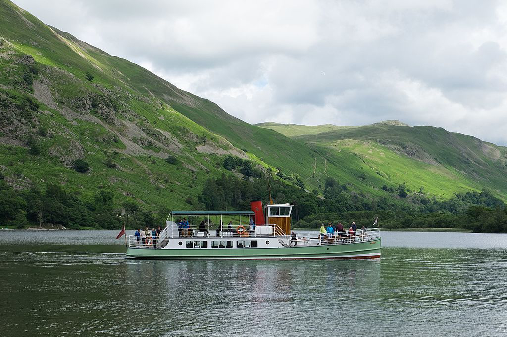
Ullswater's attractions include the Ullswater 'Steamers' which offer trips around the lake calling at Pooley Bridge, Glenridding, Howtown and Aira Force. The 'Steamers' operate all year round and were originally working boats which from the 1850s moved mail, workers and goods to and from the Greenside Mine at Glenridding, which closed in 1962. Today there are five 'Steamers' plying the waters of Ullswater. People often catch the 'Steamer' from Glenridding to Howtown and then return on foot along the lake shore to complete one of the most popular and scenic low-level walks in the Lake District.
A 20 mile walking route the Ullswater Way was officially opened in 2016 by write and broadcaster Eric Robson. The route can be walked in either direction and from any starting point. The route uses existing Public Rights of Way and quiet roads which circumnavigate Ullswater. The aim is to encourage walkers to enjoy the valley, appreciate the spectacular scenery and support local businesses.
Ullswater is very popular as a sailing location, with several sailing marinas situated around the lake. Ullswater is home to the Ullswater Yacht Club and the prestigious Lord Birkett Memorial Trophy, which is held annually on the first weekend in July. This regularly attracts upwards of 200 sailing boats and comprises two races, both of which cover the full length of the lake. There are also facilities for diving, rowing and motorboats. Another of Ullswater's attractions is the waterfall of Aira Force, midway along the lake on the western side. Ullswater lies partly within the National Trust's Ullswater and Aira Force property. Close to the falls is Lyulph's Tower, a pele tower or castellated building built by a former Duke of Norfolk as a shooting box. The prestigious Sharrow Bay Country House hotel is located on the lake's eastern shore.
Donald Campbell set the world water speed record on Ullswater on July 23, 1955, when he piloted the jet-propelled hydroplane "Bluebird K7" to a speed of 202.32 mph (325.53 km/h). In 2012, artist Robbie Wild Hudson swam the entire length of Ullswater. The swim, from Glenridding to Pooley Bridge, took 6 hours and was completed as inspiration for a project that offers paintings and drawings of the famous landscape from a different perspective. Ullswater Yacht Club (UYC) is situated on the eastern shore of the lake between Pooley Bridge and Howtown. UYC also offers a sailing school program that is open to members of the general public.

Aira Force and Gowbarrow trail
Experience Aira Force at its best as you head towards the thunderous roar of the waterfalls. Pass through woodland with lush green ferns and evergreen specimen conifers that tower over open glades. Then, emerge from the confines of the gorge to enjoy expansive views over Ullswater from the summit of Gowbarrow. This walk is Classified as Moderate. It should take two to three hours and covers four and a half miles.
Start: Aira Force National Trust car park. Take the waterfall path out of the top end of the car park, through the picnic field. Follow the path and head through a gateway in the wall into a grassy area known as the Glade. Take the left hand path through the arboretum and follow the path up to a little wooden gate on your left (which has superb views out over Ullswater to the left). Don't go through the gate but follow the path to the right, drop down a long steep flight of steps to the viewing platform at the base of the waterfall.
Continue over the bridge and climb the steep steps on the left. At the top of the steps, bear left to the upper bridge for a view down Aira Force. Rejoin the main path and walk upstream keeping the river on your left as you go. Keep going till the path takes you through a gap in the wall and then through a gate onto open farmland. Rainy days are often the best time to see the falls in full force, as rainwater runs from the fells into Aira Beck and thunders in one 65ft leap over the falls. Look out for the rainbow that appears when the conditions are just right on a sunny morning.
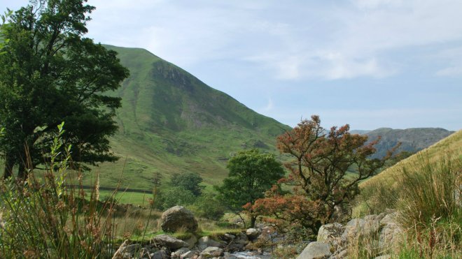
Before you get to the next gate in the wall ahead turn right up the field and take the permissive path to the fell gate. Keeping the wall on your left continue up the fellside on a good stone pitched path maintained by the Fix The Fells project, a good opportunity for a breather as you take in the views. Once the path flattens out and bears away from the wall follow the path up to the trig point on the summit of Gowbarrow. From here you have fine views all round. Look south to Place Fell and Red Screes over to Kirkstone, with the bulk of Helvellyn beyond. Blencathra, Bannerdale and Carrock Fell can be seen to the north-west, with the Pennines to the north-east. Martindale and High Street are to the south-east.
Impressive views all around can be enjoyed from the trig point at the summit of Gowbarrow Fell. It was on the west side of the fell in 1802 that Dorothy Wordsworth noticed wild daffodils growing. Her observations later inspired her brother William to write his famous poem, Daffodils.
On leaving the summit, continue along the path keeping parallel with the wall on your left. Follow the path down, bearing right until you reach the ruin of an old shooting lodge. Keeping right, continue up and around the eastern flank of Gowbarrow. Gowbarrow Park was once home to a large herd of deer, and evidence of old shooting boxes and stalkers huts can still be seen today. The deer have since been replaced by low numbers of hardy, traditional sheep such as Herdwick, to assist us in restoring heather and tree cover to the fell.
A good path takes you to the brow and down to an obvious cairn. Go over a fence stile to the superb vantage point up the head of the lake from the point marked on the map as Memorial Seat. Go back over the stile and bear left, staying on the path down towards the woodlands. At the bottom of the slope you will see across the field a building known as Lyulph's Tower (private). It was built as a hunting lodge by the Howard family in the 18th century. It was designed to look like a grand castle from the lake - from the land it appears a little more modest. Just before the woodland take the left hand fork then through a gate to rejoin the footpath bearing left back to the Glade and car park.
–
Aira Force Glencoyne Farm trail
At 1,258ha and carrying a flock of over 1,500 hill sheep, Glencoyne is one of the National Trust's largest hill farms in the Lake District. This circular trail will take you through the Grade II listed farm buildings (the earliest part built in 1629), along to the remains of old charcoal pitsteads and past Glencoyne wood, before bringing you back to the car park. With a distance of about 3 miles (4.8km) this walk will take approximately 2 hours to complete. The walk is classified as Moderate.
Start: Glencoyne car park, CA11 0QT. Turning right as you leave the car park, walk along the road crossing the bridge over Glencoyne beck. The beck marks the old county boundary between Cumberland and Westmoreland. Carry on until you come to a long straight drive up to Glencoyne Farm on your right. Take the track to the farm, carrying straight between the sheep pens, then the buildings and through the front garden. Don't worry about walking through the farm, as it's a public right of way and the farmer won't mind.
Take time to stop and admire the views of Ullswater lake and the landscape beyond. Leaving the farm, carry on up the slope and follow the path along the top of the gill on your right. You will soon spot the Seldom Seen cottages in the distance. Follow the path and this will take you underneath the cottages and out into the open fell. Seldom Seen cottages. These cottages were built in the 19th century to accommodate miners. They made their living extracting lead and silver ore from the surrounding hills.
Once past the cottages carry straight on for a short time and then bear left up a grassy slope towards the wood. Follow the path under the wall and you will come to a gate at the end of the wood. After leaving the cottages and walking up the grassy bank towards the woods, look out for round flat areas that have been cut out of the bank. These are called charcoal pitsteads and are burning platforms where charcoal was produced 100 years or so ago. There are many pitsteads in this area indicating that there was once much more woodland here.
Go through the gate and turn left over a stile and into the wood. Follow the path down through the wood and you will return to the cottages below. When walking back through the wood look out for red squirrels. You may be lucky and see one. Glencoyne wood was a much better place to see red squirrels before the arrival of grey squirrels. Once past the cottages, follow the track all the way down to the A592 road. At the road go straight across and join the footpath, then turn left and take the path to the bottom of the hill. The path then joins the road which will take you past Glencoyne Farm drive and back to the car park.
–
Aira Force Glenamara Park trail
Affording stunning views of mountains and water, this easy walk on paths is suitable for all - but bring waterproof boots depending on the season as it can get pretty wet underfoot! The walk is classified as Easy and is about 2 miles long. It should take approximately one hour and is dog friendly.
Start: Patterdale Hotel CA11 0NL. From the Patterdale Hotel car park turn left along the road, with the hotel on your right heading towards the White Lion pub. Having gone past the pub and the shop turn to your right heading up past the car park on your left passing the public toilets as you go. Follow the track and you will pass a small building on your right. Once past this small building bear left through the trees and left again towards a gate in the fence. Go through the gate and follow the path up out onto the open fell.
If you visit during the months of May and June you will see a wonderful display of bluebells. This is an ancient woodland flower indicating that there has been woodland on this site for hundreds of years. Keep following the path and you'll come to a field gate and a kissing gate together. Go through the kissing gate and you're now entering Glenamara Park. Notice the very high wall to your left; this is the deer wall which encloses the park. Glenamara Park is an old deer park and is encircled by a very high dry stone wall, much higher than ordinary dry stone walls as they were designed to keep the deer in.
The path takes you along the bottom of Glenamara Park crossing Hag beck which runs down the middle. Take a minute to look at the wonderful views down the lake towards Glencoyne Park and Gowbarrow in the distance. Carrying on along the path you'll pass under two old oak trees on your right, you'll see a small wooden gate below leading out into a field. Go through this gate and follow the track down to the road below. Associated with the old deer park are the veteran trees which are dotted along the walk. The one to look out for is the hollow alder tree just through the gate into the park.
Go through the gate and out onto the road and turn right. Follow the road down the hill until you come to main A592 road. Turn right and follow the road back to the Patterdale Hotel which is about 400 yards away.
–
Aira Force Hayeswater Gill trail
Hayeswater Gill runs down from Hayeswater reservoir, which once contributed to the water supply for north-west England. In the past the water powered a corn mill, turning a water wheel that pumped out water from a nearby lead mine - which you can still see today. This walk is classified as Moderate. It is around two miles long and will take about two hours to complete.
Start: Hartsop village car park, CA11 0NZ. From the car park take the gate in the corner and follow the track past the sheep pens on your right. Proceed along the tarmac road with fine views of Grey Crag to the front and Hartsop Dodd to the right. The lucky sheep at this farm certainly have a pen with a view. Take in the fine views of Grey Crag to the front and Hartsop Dodd to the right as you pass. The sheep pens just beyond the car park were built in the early 1980s and are an important part of the farm. Pens are where the sheep are gathered from the surrounding fells to be sorted and either treated or dipped. Sheep pens are nearly all the same design with the dipping tub and a round pen in the middle.
After crossing the cattle grid, keep to the tarmac road and you will come to a gate. Once through the gate follow the road until you come to the old filter house which at one time filtered the water from the reservoir. Along the walk look out for the numerous ash tree pollards. Pollarding is the removal of branches above the reach of grazing animals and was carried out by farmers to feed the animals in winter and also for fuel for fires. In the Hartsop area there are over 250 ash pollards which we continue to pollard today. These old trees are usually hollow and are a vital habitat for bats, birds and a variety of deadwood insects.
Take the path below the filter house and follow it down to the beck coming down from Hayeswater. Cross the beck using the small footbridge and climb up to the main track ahead. Once on the track, if you wish you can carry on up to the reservoir which is about 600m away. On the fells around Hartsop you often see herds of red deer. These deer are part of the Martindale herd of which there are around 600. During the winter months they come down to the low land areas to graze and occasionally you can get a close look at them.
If you don't carry on to the reservoir, turn back down the track and follow it down through a gate and to the bottom of the slope, passing an old hogg house as you go. After walking a short distance you will cross another bridge. A short distance after crossing the bridge, turn left down the field with the beck on your left. You will now see in front of you several stone piers that supported a wooden trough carrying water to the wheel pit below. When reaching the wheel pit at the bottom of the field you can see Myers Head Mine - a walled structure across the beck. Turning right and keeping the beck on your left follow the path until you come to a wicket gate in the wall.
Once through the wicket gate, bear right and follow the drier grassy path over a little footbridge towards another stone structure. This is the old corn mill with the sandstone wheel still visible in the ground. In the field just below the road lies the remains of the old corn mill, thought to be of 18th-century origin and last used around 1900. On the way back you can have a look and see the old sandstone wheel. Carry on past the corn mill and you will rejoin the tarmac road with the sheep pens ahead. Follow the track back to the start of the walk and the car park.
Information, snacks and gifts are available from the shop in the main Aira Force car park. The Aira Force tea room sells drinks, light lunches and cake. Three car parks at Aira Force and one at Glencoyne Bay. Aira Force Car Park: £5 for 2 hours, £7 for 4 hours, £9 all day. NT Members park for free. Booking is essential for coach parties. No access for coaches during busy holiday periods. Glencoyne Bay & Park brow Car Parks: £4.50 for 2 hours, £6 for 4 hours, £7 all day. High Cascades Car Park: £4 for 2 hours, £5.50 for 4 hours, £6.50 all day. NT members park for free.
The walk up to the waterfall is a leisurely stroll along a well maintained path, suitable for small explorers. Kids can tackle Cyril's red squirrel ramble around Aira Force. Find the squirrels, answer the questions and become a squirrel detective. Pick up a booklet from the welcome building. Explore the woodland glades and enjoy our fascinating collection of trees on the tree trail. Paper trail available from the welcome building £1. Most grounds are difficult for pushchairs.
There are Mobility parking spaces. There is a Mobility toilet adjacent to the car park entrance. Much of Aira Force and the countryside is steep and rugged. The Waterfall not accessible by wheelchair. There is a new off-road footpath from Aira Force to Glencoyne Bay, the rest of the walk to Glenridding is mainly off-road but is rugged. Outdoor footwear is advised. Assistance dogs are welcome. Ullswater steamers are perfect for the mobility impaired.
Ullswater Steamers have been sailing on England’s very own “Lake Lucerne” since 1859. The steamers provide the perfect opportunity to combine a cruise with some of the most famous and spectacular walks in the Lake District.
Ullswater Steamers boast the following facilities: A fleet of five classic beautifully preserved vessels; The main landing stages are at Glenridding and Pooley Bridge; Easy accessible wide (100cms) board walk ramp to reception/booking area; Disabled toilet facility in main area; Tearoom/coffee bar with movable seating; Information TV screen; Accessible outdoor seating area with picnic benches; Gift Shop; Accessible meadow area with seating; Large car park, with disabled parking spaces by main entrance; Wheelchairs are available if required; Motorised chairs and mobility scooters are not allowed on the piers; Special portable ramps allow access onto the vessels; Hearing loops at both Pier Houses; Free wi-fi and audio commentary app; Dogs are welcome.
The other landing stage at Pooley Bridge has all the above facilities but has no car parking apart from a small drop off area and bus stop. We would recommend that you start your lake cruise from Glenridding Pier. Both Pooley Bridge and Glenridding are served by Stagecoach easyAccess services (subject to availability) 108 & 508 from Penrith Railway station and Bus station. Approximately 20 minutes to Pooley Bridge and 45 minutes to Glenridding . Keswick and Windermere services in main holidays.
Location : near Watermillock, Penrith, Cumbria, CA11 0JS
Location : Ullswater steamers, Glenridding CA11 OUS
Transport : Penrith (National Rail) 10 miles. Bus Routes : from Penrith train station to Patterdale
Opening Times : Dawn till Dusk; Shop and Tea room 10:30 to 16:30
Opening Times : Ullswater steamers Timetable
Tickets : Free
Tickets : Steamer single - Adults £6.80; Children £3.40
Tickets : Steamer return - Adults £10.80; Children £5.40
Tel : 017684 82067

