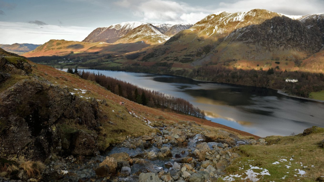
Buttermere is a lake in the English Lake District in North West England. The adjacent village of Buttermere takes its name from the lake. Historically in Cumberland, the lake is now within the county of Cumbria. It is owned by the National Trust, forming part of their Buttermere and Ennerdale property.
The lake is 1.25 miles (2,010 m) by .25 miles (400 m) wide, and is 75 feet (23 m) deep. It has an elevation above sea level of 329 feet (100 m). A place of considerable scenic value, it is situated towards the head of the valley of the River Cocker and is surrounded by fells, notably the High Stile range to the south west, Robinson to the north east, Fleetwith Pike and Haystacks to the south east and Grasmoor to the north west.
The village of Buttermere stands at the north western end of the lake, and beyond this is Buttermere's twin, Crummock Water. There is a path around the lake which is about 4.5 miles (7.2 km) long, and at one point runs through a rock tunnel beneath the locality of Hassness. Access is by road, from Cockermouth in the north west; from Borrowdale via the Honister Pass; or from Braithwaite and the Newlands Valley via Newlands Hause.
There are two possible origins for the name "Buttermere": One, that Buttermere means "the lake by the dairy pastures" (from the Old English "butere mere"). Whaley suggests this as the correct interpretation: " 'butter lake, the lake with good pasture-land', from OE 'butere' 'butter', conveying the fertile nature of the flat alluvial land at both ends of the lake, plus 'mere' 'lake',..."
Two, that it is the corrupt form of a personal name. Robert Ferguson asserts in his 1866 work, "The Northmen in Cumberland and Westmoreland" that Buttermere derives from the Old Norse personal name "Buthar", as in "Buthar's mere" (lake). This accords with local tradition, which says that the valley of Buttermere was part of the holdings of an 11th-century Norse chieftain called "Buthar" (sometimes spelt "Boethar"). Large numbers of Vikings settled in the Cumbrian area during the 9th and 10th centuries and many names in the area are of Norse origin: streams are termed 'becks', from the Old Norse bekkr; mountains are 'fells', from the Norse fjall; waterfalls are forces, from fos; ravines are 'gills'; valleys are 'dales', from dalr (ON); and small lakes are termed 'tarns', which derives from tjorn, meaning teardrop. Whaley suggests that the personal name interpretation is incorrect, but notes that the Victoria County History "deemed it 'not disputed that the family of the Scotic ruler, Bueth or Boet, held its own against the Norman intruder', with possession of the barony of Gillesland, for fifty years after the Norman Conquest."
Whatever the origins of its name, and despite it rugged surroundings, Buttermere Valley has a long history of settlements and people. One of the most famous residents of Buttermere is Mary Robinson (1778-1837). Known as the Maid of Buttermere, Mary was the daughter of the landlord of the Fish Inn in the village and she was the subject of Melvyn Bragg's 1987 novel of the same name.
Maid of Buttermere.
Mary Robinson, who was to become known as the “Maid of Buttermere” was the landlord’s daughter at the village inn, now the Fish Hotel, where travellers and locals would enjoy a glass of ale and a meal in the family kitchen. She had little knowledge of the world beyond the valley, meeting only those that grew up in the village and happened to pass through the inn doors.
In 1792 Joseph Budworth “discovered” fifteen-year-old Mary at the inn during one of his frequent walks across the Lake District, researching material for articles and guidebooks he was writing. He was so amazed by her beauty that he included her as a tourist attraction for the valley in his article to a London newspaper. He expanded on this in his guidebook ‘A Fortnight’s Ramble to the Lakes’. Budworth described her in rapturous terms “her face was a fine oval face, with full eyes and lips as sweet as vermillion”, and compared her to an angel.
Many people came to Buttermere just to see her. William Wordsworth, wrote about her in The Prelude. Budworth himself returned after six years and lectured her on not letting the fame go to her head, but the fame she had never sought was to bring bad things with it.
In the Autumn of 1802 Mary was swept off her feet by one Alexander Augustus Hope, who claimed to be the brother of Lord Hopetoun, and was travelling through the Lake District and decided to come and see her acclaimed beauty for himself. After a whirlwind romance, the two were married in the church at Lorton on 2nd October.But there was no happy ever after for Mary. Just a few days after the wedding, her husband was summoned to Keswick for non-payment of bills. Once in the town he was accused of stealing Alexander Hope’s identity, forging cheques and being a thief and a liar! Hope persuasively talked himself out of trouble and left the town on the Buttermere road ostensibly to return to his new wife. At the end of the valley, however, instead of turning right over Honister Pass back to the Buttermere Valley, he turned left, up the Langstrath Valley and disappeared.
Constables were dispatched to find him and in December he was arrested in North Wales under his real identity of James Hatfield. He was brought back to the Lake District and imprisoned, then hanged at Carlisle jail for his crimes of forgery. Mary was devastated to hear that her beloved husband was a liar and already had a wife and child. Mary had a child by Hatfield, which died of pneumonia after just three weeks. She was later to marry again and moved to Caldbeck, in the north of Cumbria, where she lived out the rest of her days married to a local farmer. Her gravestone is in the churchyard there.
Fanny Mercer.
The white cross on the side of Fleetwith Pike and overlooking Buttermere marks the sad story of Fanny Mercer. Fanny was a young servant girl who worked for Mr. Bowden Smith, a school teacher from Rugby, and accompanied his family on their summer vacation in the Lakes.
One fateful day in September 1887, the party were walking to the top of the crag above Honister Quarries and were descending down the steep ridge of Fleetwith Pike. Fanny was not an accomplished walker and during this part of the journey she jumped down from a ledge and lost her balance. She fell a distance of around twenty feet amongst rocks and rabble until she reached the bottom of the fell side. By the time the others had reached her, she was badly injured and taken to the nearby Gatesgarth Farm, but sadly died before medical assistance could arrive.
Her body was returned to Rugby where she was buried and the white cross erected in her memory in Buttermere. To this day the symbol stands as a warning to walkers that the mountains of the Lake District can be perilous unless you are alert and mindful of the dangers.
Nicholas Size.
Nicholas Size had grand ideas for Buttermere. He owned the hotel in the centre of the village, known today as the Victoria Hotel, and dreamed of transforming this quiet valley into something that could rival the Alpine ski resorts. He envisioned a chair lift to the top of High Crag, constructing a large beer garden behind the hotel complete with an oompah band and wanted to develop the services for the growing numbers of motorists passing through (a revolutionary thought for the time).
Unfortunately many of these dreams were to remain just that; although he did create a few tea gardens! Perhaps his greatest accomplishment was a nine hole golf course in the fields leading down to Crummock, known locally as ‘the Golf Links’. Despite this lack of fruition, ‘Auld Nick’ was a much-loved character of Buttermere. He championed the idea that people were free to experience the countryside, which caused controversy with many local landowners. He enjoyed the company of others and spent many days chatting to visitors in his hotel. His name lives on in his book ‘The Secret Valley’, which is based on Buttermere and tells the story of how the Normans attempted to conquer the inhabitants but were repelled by the fierce local spirit.
Nicholas was buried in his own plot of land on the rocky fell side above the Bridge Hotel, at the head of the Fairy Glen. Unfortunately for Nick, his funeral was marred by dreadful wet weather, which meant his coffin had to be lowered into the water-filled grave with stones placed on top to hold it down. Thus ended the story of one of Buttermere’s most colourful characters. The epitaph, which he wrote himself reads: ‘’No tombstone virtues will ornament my grave, No over confidence about my Salvation, Write me down one that loved his fellowmen And was a credit to his generation.’’
–
Wintery waterfalls in Buttermere Valley.
Slate grey skies, wet rock gleaming like mica, and the exhilarating rush of white water hurling itself into space. Bring a touch of drama to your winter walks in the Lake District with the waterfalls of the Buttermere Valley. The Lake District is famous for its rain, and the silver lining it brings is that the waterfalls achieve a majesty and a raw power that they only rarely achieve in summer. Tiny crevices in the rock that would normally pass unnoticed suddenly blaze out a stark white against the dark ground as the water turns every gill and crack and chimney into a cascade that lasts only as long as the shower.
The Buttermere Valley has quite a few of these beauties, so in the Nordic tradition that there’s no such thing as bad weather, only inadequate clothing, the National Trust recommend getting thoroughly togged up before heading out to experience them.
Sourmilk Gill. Sourmilk Gill is impossible to miss. It thunders and creams down nearly 400m (1,300ft) of steep fellside from Bleaberry Tarn to Buttermere in one headlong cascade through the trees. When it’s in spate its power is awesome – during the 2009 floods it brought pink granophile boulders the size of microwaves crashing down from Red Pike until it completely filled the channel beneath the footbridge. There is a pitched footpath up beside Sourmilk Gill to Bleaberry Tarn, but it’s very steep and the stones can be extremely slippery in wet conditions.
Scale Force. Scale Force is the tallest single drop waterfall in the Lake District. About an hour’s walk from Buttermere village, it’s a shy waterfall that hides deep inside a narrow rock gorge above Crummock Water. The Victorians used to take a rowing boat from the opposite side of the lake, then walk up a set of wooden steps to view the long fall. To view it these days involves scrambling up a large boulder which is slimy with moss at the best of times. A safer experience is to stand on the footbridge and listen to the roar of the water echoing in the gorge.
Holme Force. Holme Force is the least-known of the waterfalls in the valley. A gentle walk through Holme Wood beside Loweswater, rising up a forest track leads you to the base of this series of falls which spout from moss-covered rock arches to form a series of mysterious pools. Locals call this fall the ‘Grey Mare’s Tail’.
Moss Force. If the road isn’t icy, take the narrow winding Newlands Pass road to the layby right at the top at Newlands Hause. From the layby you get a great view of Moss Force crashing down a dramatic black crag from High Snockrigg. There’s also a short path that will lead you closer to the falls, (it will be very slippery in wet conditions).

Loweswater is a peaceful little lake with a specially upgraded accessible footpath as part of the Miles Without Stiles project. It is unique in that it is the only Lake District lake where the water flows back into the park and away from the sea.
There is a circular walk around the lake which follows the lake shore and makes its way through Holme Wood - a small mixed woodland which runs down the south west side of Loweswater, and is populated by deer and red squirrels. In the wood is Holme Force - a waterfall of great beauty, which is rarely visited as it is not noticeable from the lakeside path. It's local name is 'the grey mare's tail'.
Right on the lakeshore in Holme Wood is a little stone bothy. This is a National Trust camping barn, heated by open fire which you can rent out for a short break in the wilds. Wake up with a coffee on the beach as the sun comes up, or sip a glass of wine while doing some star-gazing. It's simple, but beautiful. The hamlet of Loweswater is the home to Kirkstile Inn which provides traditional pub meals and bed and breakfast accommodation. The inn is surrounded by woodland and fells, and is only half a mile away from both Loweswater and Crummock lakes.
On shallow slopes and under the influence of the Lake District’s notably damp climate, peat soils can develop, sometimes to a great depth. One good example of this specialist habitat lies in the upland valley to the south of Loweswater; it is known as Whiteoak Moss.
The remains of growing bog-mosses have accumulated over millennia, as they only decompose partially due to the saturated, oxygen-free conditions of the peat soil. Across a wide area the peat is now a metre deep and this volume of organic soil traps a great deal of carbon. As the peat accumulates more carbon is stored – a carbon `sink`. Such wet, peat soils are unsuited for the growth of many plant species and the vegetation found is quite specialist. Most important of all is the carpet of bog-mosses ('Sphagnum' species) which continue to absorb water like a huge sponge and keep the blanket bog continually moist.
Growing through this moss layer are species such as cotton-grasses, crowberry, cowberry, cross-leaved heath, deer-sedge and real specialists like bog rosemary and sundews. Both round-leaved and oblong-leaved sundew can be found and both rely on catching small insects on their sticky hairs to supplement the poor nutrient supply from the peat. As well as specialist plants the blanket bog is also home to many well-adapted invertebrates, the most prominent of which are the emperor and fox moths, both of which fly during the day. Meadow pipits are frequent here and can be seen and heard doing their `parachute` display flights in spring.
Blanket bog is not just a fantastic wildlife habitat but is also incredibly important in other ways. The peat soils contain vast amounts of stored carbon and, whilst there is an active layer of bog-moss growth, the carbon store continues to increase. Bog-mosses can retain many times their own weight of water and as a consequence blanket bogs can soak up rainfall, slow the run-off and help alleviate possible flooding.
–
Buttermere (the lake) offers one of the best round-the-lake walks in the Lake District. The walk is relatively easy and level with a great 'reward for effort' ratio. The views mean that your photos make it look like you've been somewhere much more rugged. The most popular view is looking down the lake towards Fleetwith Pike, which drops in a near vertical cliff down from the summit towards the infamous Honister Pass of 'Tour of Britain' fame. The lush green fields beside the lake nestle beneath a lowering natural amphitheatre of black rock where Fleetwith meets Haystacks - Alfred Wainwright's favourite fell.
Buttermere lakeshore path circles the lake for 4½ miles (7km) with one very short stretch on the road and one 'rock step' (short scramble) where you may have to use your hands. The National Trust recommend that you allow three hours - you'll want to linger on the way and watch the shadows / waves / mist / sun - depending on what it's doing on the day. Walking with children? They recommend going anticlockwise around the lake. You get to start off through the woods where you'll be a bit more sheltered from any wind. Then on the way back towards the village, you get the added excitement of a tunnel which was carved out in the 19th century by a Manchester Mill owner.
The permissive path along the north end of the lake (closest to the village) closes from 1st April - 30th June each year so that the resident sandpipers can nest in peace. These ground nesting birds are particularly vulnerable to being disturbed by dogs and people. You can still walk round the lake, however - it just means that you need to decide which way you're going before you leave the village.
There are two hotels in Buttermere: 'The Fish' and 'The Bridge'. 'The Fish' was made famous by the story of Mary Robinson the landlord’s daughter, who was known as ‘The Maid of Buttermere’ after being mentioned in a guidebook as a local beauty! She was later involved in a national scandal when a man posing as a colonel married her bigamously – he was later hanged at Carlisle for forgery. As well as its hotels, Buttermere has two cafés that provide refreshments. Both cafés sell local products with Syke Farm specialising in ice cream made from the milk from the farm’s herd of Ayrshire cattle.
Buttermere to Rannerdale walk.
This exhilarating Lakeland ridge walk climbs from the Buttermere Valley up to the summit of Rannerdale Knotts. Though it’s one of the smaller and more rounded Cumbrian fells, the route gives stunning views over three lakes and many high peaks. It returns via the shoreline of Crummock Water and Nether How woodland to the pretty little village of Buttermere. A dog friendly walk, this is classified as Moderate, should take about two hours to complete and is 3 miles long.
From the starting point at the National Trust car park in Buttermere walk straight across the road to a stile. Cross the stile and follow a narrow grassy track until the path begins to get steeper. Sometimes known as the Secret Valley, this area is said to be the site of a battle at which native Cumbrians and Norsemen ambushed and defeated Norman armies in the century after they came to Britain in 1066. Rannerdale offers a popular bluebell walk in spring, when the woodland floor becomes an indigo carpet. Local folklore suggests that the bluebells have sprung up from the blood of slain Norman warriors.
As the path steepens, take the left-hand track leading towards the ridge of Rannerdale Knotts. This is a good point to pause and enjoy the view over to Buttermere lake and the surrounding hills, such as High Snockrigg in the east. Beatrix Potter's beloved Herdwick sheep, for which she won many breeding prizes, can be seen grazing on the fells all year round, with the exception of lambing time when they are moved to the lowlands. Their lambs are born with wool which is almost black; it gradually turns lighter with age.
Follow a gentle incline along the ridge to the summit, offering another superb panorama of both Rannerdale (or the secret valley) and Crummock Water. Soon you reach the highest point cairn (they would appreciate it if you didn't add stones to the cairn, paths need stones much more than cairns do!). Crummock Water is located between the two lakes of Buttermere and Loweswater; all three are owned by us. Crummock literally means crooked, and refers to the lake's shape. The lake is deep, up to 144ft (44m), making it cold and clear, great for taking a boat out on.
From the summit, follow the narrow, winding, grassy track to your left downhill towards Crummock Water. The track leads you to a very steep, stone-pitched section. This area can become slippery during wet weather, so take care. When you leave the pitched section follow the track further downhill until it branches left and gently descends towards a road. Cross the road and go through a gate leading to the lakeshore. Walk alongside the lakeshore until you see a gate to your left leading into Nether How woods. Enjoy the view from the Rannerdale Knotts looking down the ridge into the Secret Valley. Crummock Water and Loweswater can be seen in the distance. Loweswater is one of the smallest lakes in the Lake District and has a more gentle and rolling landscape than its neighbours.
Go through the gate and follow the path through the wood. The path briefly leads to the lakeshore again before re-entering the wood. Take a path to your left leading through Nether How wood to a footbridge. Flanked by the steep fellsides of Grasmoor to the east and Melbreak to the west, Crummock is fed by lots of streams, including the beck leading from Scale Force, the highest waterfall in the Lake District, which is 2.5 miles (4km) from Buttermere and a circular 2 hour walk. It's home to lots of wildlife, including the rare Arctic char, a fish closely related to both salmon and trout.
Cross the bridge and follow the path to the right, through the woods until you return to your start point. Alfred Wainwright (1907-1991), the author of the Pictorial Guides to the Lakeland Fells, made this area famous with his hand-written and hand-drawn guides to the lakes. There's a memorial to him at the church in Buttermere village and his ashes were scattered on Haystacks, his favourite mountain in the Lake District.
Fairly strenuous route in all weathers; sturdy boots and clothing essential. Mostly on grassy paths, with a steep, stone-pitched descent of Rannerdale Knotts. Dogs are welcome but please keep them on leads. Toilets, pubs and café available in Buttermere village.
Corpse Road and tumuli walk.
Get under the skin of the Cumbrian landscape on this trail through a patchwork of natural and archaeological features. Discover a traditional farm, walk along an ancient Corpse Road and find evidence of human activity dating from the Bronze Age to the Second World War. This walk is classified as Easy, it is 3.6 miles long and should take about two and a half hours. It is described as dog friendly.
Start at Maggie's Bridge car park in Loweswater. Go through the gate opposite and follow the track up to High Nook farm, where you will see fine examples of traditional Cumbrian farm buildings. High Nook is a working farm featuring traditional architecture typical of the Lakeland style. We have worked with the local tenant farmer to preserve the historic hay meadows here. Watch out for farm vehicles and machinery and keep dogs under close control.
Leave the farmyard through the gate and bear slightly left. Follow this wide gravel track up towards High Nook Tarn and take the path veering right. You are now on part of the Corpse Road which leads from Buttermere to Lamplugh church, and onwards to St Bees Priory. Follow this parallel to the wall and be sure to take in the great views when a gap in the woodland appears. Go through a small gate in the woodland wall and follow the steep, narrow downhill track. When you reach a wider forestry track, turn left.
It's worth pausing here to look at Holme Force waterfall and the single span stone bridge which crosses Holme Beck. Follow the forest track downwards until you meet another intersecting track. The waterfall at Holme Force can be a particularly spectacular sight after rain, when Holme Beck is in spate. Follow the narrow track towards the lakeshore and turn right. You will come across a rectangular platform on your left. This dates from the Second World War, when cables were stretched across the lake, with the intention of thwarting any German sea-planes attempting to land here.
Beautiful views of Loweswater can be seen from an opening in the woodland at direction point 6. Great crested grebes, tufted ducks and cormorant are amongst the many birds to be seen around the lake. The woods also contain a healthy population of red squirrels. As you near the Bothy (the National Trust camping barn) you may notice two burial mounds near the path. Continue out of the woods and across the hay meadows back to the car park.
Varying terrain with a gradual climb to High Nook, paths can be slippery when wet and suitable footwear and clothing is recommended. The route is not suitable for pushchairs. Dogs welcome under close control, but please do not allow your dog to foul on paths and around picnic areas. No bins provided - please take all litter, including dog waste, home.
Lanthwaite Wood and Crummock Water walk.
This walk is dominated by two spectacular views: the famous vista of the Buttermere fells seen over Crummock Water, and the dramatic rocky buttress of Grasmoor End, looming over the northern end of the lake. The walk is classified as Moderate. It is four miles long and should take about two and a half hours. It is described as dog friendly.
Leave the car park through the small gate at the far end from the road, turn right onto the footpath that runs alongside the River Cocker and follow it all the way to Crummock Water. After heavy rain this path can be quite wet - if this is the case, follow the forest track instead. The path brings you to the source of the Cocker, and one of the district's best viewpoints. From here, follow the track running along the left-hand side of the lake through Lanthwaite Wood, followed by the very different High Wood.
Although they look peaceful now, the shores of Crummock Water were once the site of early industry. On this route you'll pass the site of one kiln, now under a bench, and a bloomery site, the earliest form of iron production, found where the path actually runs along the beach. Look for fragments of waste iron slag amongst the rocks on the beach (but please leave them here). The lakeside path passes through two large fields after leaving High Wood, then enters a long narrow field filled with gorse bushes. Follow the path along the lake shore to the far end of this field, then turn left and follow the grassy path that climbs up to the higher side of the field. Turn left, staying inside the field, and follow the path that runs along the upper edge of all three fields back to High Wood.
At High Wood a gate leads onto a road. Cross this road, then head straight across the hillside, towards Grasmoor End (look for a suitable path through the bracken). This brings you to a major path running across the hillside. Turn left onto this path and follow it all the way to Liza Beck where it emerges from Gasgale Gill, between Grasmoor and Whiteside.
Turn left at the beck, and head down the line of an old drainage ditch towards the Iron Age homestead, a series of sunken platforms between the ditch and Liza Beck. After exploring the homestead continue on in the same direction towards the road you crossed earlier. Note the depth of the sunken platforms that once held the buildings of an Iron Age or Roman village on Lanthwaite Common. These platforms were dug out to make some level space for a house, and the spare soil was used for banks around the village. Turn right onto the road, then left onto the next signposted footpath running along a narrow lane between stone walls. Follow this to the edge of Lanthwaite Wood.
Just inside the woods, turn right onto a narrow footpath. This follows the edge of the wood, then climbs up onto Brackenthwaite Hows, once a famous 'viewing station'. The view from Brackenthwaite Hows was a fixture for Victorian tourists, and was mentioned in an 1879 guide as 'The Station', attached to the old Scale Hill Hotel. You will see both views on your walk: from the lakeshore, dominated by the water, or from the hilltop, with many more fells visible.
Brackenthwaite Hows has two summits. Follow the path from the first to the second, then curve away to the left to follow a ridge that leads towards a stile leading into the woods. Follow the path as it drops down Dick Robins' Steps, and then onto a forestry track. Turn left onto this track, then right at the next junction to return to your starting point. The stone steps between the hotel and the viewpoint are known as Dick Robins' Steps and and were probably cut by the hotels owners. They were possibly named in memory of Richard Robinson, a 16th-century landowner who purchased land here after the dissolution of the monasteries.
Some rough or wet paths and two climbs - one across Lanthwaite Common and one onto Brackenthwaite Hows. Also steep steps down from Brackenthwaite Hows. Dogs welcome under close control. Please do not allow your dog to foul on paths or around picnic areas. No bins provided - please take all litter, including dog waste, home.
–
Toilet facilities (non NT) in Buttermere village. Pubs, café and ice cream in Buttermere village. Dogs are welcome, but please keep them on leads. Part of the Buttermere lakeshore route will be closed in the bird nesting season (April to June). National Trust staff based on Buttermere lakeshore except in winter months. Fishing permits and boat launch permits available, daily weekly and seasonal rates (including members). There is a Special Easter event every year. There is an Access for all path on SW shore of Buttermere. There is an Access for all path from Lanthwaite Wood car park to Crummock Water. There is an Access for all path from Maggie's Bridge car park along Loweswater SW shore.
Location : Buttermere, near Cockermouth, Cumbria, CA13 9UZ
Transport: Workington OR Penrith (National Rail). Bus: Honister Rambler service 77 from Keswick to Buttermere (April to October)
Opening Times: Dawn to dusk
Tickets : Free
Tel: 01900 824805
