Orford Ness is a cuspate foreland shingle spit on the Suffolk coast, linked to the mainland at Aldeburgh and stretching along the coast to Orford and down to North Weir Point, opposite Shingle Street. It is divided from the mainland by the River Alde, and was formed by longshore drift along the coast. The material of the spit comes from places further north, such as Dunwich. Near the middle point of its length, at the foreland point or 'Ness', lies the Orfordness Lighthouse. In the name of the lighthouse (and the radio transmitting station), 'Orfordness' is written as one word.
Salt-marsh built up behind the shingle spit as it formed, and eventually local people used these areas for grazing. This could have started long before records began, but some time in the medieval period walls were built around the marshes to control and eventually exclude the tidal river water. Henry II built the castle in Orford village and it's likely that he is the king referred to in the name of southern marshes, the 'King's Marshes'.
The lonely and bleak spit of land became the haunt of poor folk collecting gull's eggs for food, fishermen and the marshmen who tended the cattle and sheep. Strange tales arose, most notably the famous Orford mere-man fished out of the river and a winged crocodile-beast that attacked boats. The spit and sandbanks that lie off it were deadly to mariners and many lost their lives - over 30 ships were lost in one great storm in 1627. The problem was solved by lighthouses, which have stood on the Ness ever since. The sea has claimed those early lights and even threatens the current one, built in 1792.
Smuggling was rife along the creeks and estuaries of the Suffolk and Essex coasts. Remote and uninhabited, the spit was a natural haunt for smugglers such as Margaret Catchpole and William Laud. Their story was immortalised in the semi-fictional book Margaret Catchpole, written by the Rev. R. Cobbold. Revenue men, forerunners of the coastguard, patrolled and an early beach-launched lifeboat, a revenue cutter and later a coastguard lookout were also established close to the lighthouse.
Throughout the reigns of the Stuart and Hanovarian monarchs, the peace of Orford Ness came increasingly under threat. Footpads and criminals weren't the only threat along the coast. The lighthouse was attacked by French privateers in the 17th century and a naval skirmish - the Battle of Orford Ness - featured during the wars with the Dutch. Part of the larger St James Day Fight (Battle of North Foreland) fought on 25 & 26 July 1666 saw the Dutch lose 20 ships to only one English casualty, the Resolution.
The many flat, cliffless beaches and deep estuaries of Suffolk make it an ideal invasion target. The spit provides an effective invasion defence but where it joins the main land at Aldeburgh is a potential weak spot. The great Martello tower at Slaughden where the spit just touches the mainland is the largest and most northerly of the coastal towers built against a potential Napoleonic invasion. You can stay in the Slaughden Martello Tower, which is now owned by the Landmark Trust. (There is no access onto Orford Ness from Slaughden or Aldeburgh.)
Throughout these more troublesome times, the marshes continued to be used for grazing. Mussel beds were dug in the salt-marshes in Stony Ditch and by the end of the 19th century, two marshmen's houses stood on the spit - one in King's Marsh and 'The Hazard' near Slaughden.
A large part of Orford Ness was purchased by the War Department in 1913, with the whole of the site acquired soon after. From 1913 Orford Ness was used as a military test site and closely guarded to prevent public access. Top secret experiments were conducted across both World Wars and into the nuclear age.
Between August 1913 and the summer of 1916 the southern half of the King's Marsh was drained and levelled to form airfields to the left and right of the road. The site was ready to receive its first aircraft in 1915. This was perhaps the most significant turning point in the history of the Ness, with the arrival of part of the Central Flying School's Experimental Flying Section from Upavon in Wiltshire. This was the start of 70 years of intense military experimentation, which as well as leaving a variety of physical traces, has given the place what has been described as 'the mystique of secrecy'.
The longevity as a place of military experimentation is significant. The arrival of the military curtailed the traditional uses of the Ness by the local population, although the station soon became an important source of employment for them. Most of the experimental work related to aerial warfare. Significant advances were made in both military hardware and experimental techniques and equipment. Amongst the pioneering work of the First World War were early experiments on the parachute, on aerial photography and on bomb and machine gun sights as well as evaluation of aircraft and the development of camouflage.
After the War Orford Ness was put on a 'care and maintenance' order until 1924 when it was reopened as a satellite of the Aeroplane and Armaments Experimental Establishment at nearby Martlesham.
The site was selected as the location for the Orfordness Beacon, one of the earliest experiments in long-range radio navigation. The Beacon was set up in 1929 and used in the pre-war era. In the 1930s Orford Ness was the site of the first purpose built experiments on the defence system that would later be known as radar. Having proved the technology on Orford Ness Robert Watson-Watt and his team moved to nearby Bawdsey Manor and developed the Chain Home radar system in time for its vital role in the Battle of Britain.
The Atomic Weapons Research Establishment had a base on the site, used for environmental testing, i.e. when a laboratory test is conducted to determine the functional performance of a component or system under conditions that simulate the real environment in which the component or system is expected to operate. Many of the buildings from this time remain clearly visible from the quay at Orford, including the distinctive "pagodas". Whilst it is maintained that no fissile material was tested on the site, the very high explosive initiator charge was present and the buildings were designed to absorb any accidental explosion, allowing gases and other material to vent and dissipate in a directed or contained manner. In the event of a larger accident, the roofs were designed to collapse onto the building, sealing it with a lid of concrete and shingle.
In the late 1960s an experimental Anglo-American military over-the-horizon radar known as Cobra Mist was built on the peninsula. It closed in 1973, and in the late 1970s and early 1980s the site and building were re-used for the Orfordness transmitting station. This powerful mediumwave radio station – originally owned and run by the Foreign Office, then the BBC and, after privatisation in the 1990s, a series of private companies – was best known for transmitting the BBC World Service in English around the clock to continental Europe on 648 kHz from September 1982 until March 2011. The following year the site became disused until Radio Caroline began broadcasting from the site in December 2017.
Orford Ness is now owned by the National Trust and is open to the public under the name "Orford Ness National Nature Reserve", though access is strictly controlled to protect the fragile habitats and due to a residual danger to the public from the site's former use by the military. Access is therefore only available by the National Trust ferry from Orford Quay on designated open days.
Rachel Woodward writes: “ It is a place of strange contrasts. For the National Trust, its 'elemental nature' contrasts with the 'inherent dangers' of this place, a 'hostile and potentially dangerous site'. Military structures – the Bomb Ballistics Building, the Black Beacon, the 'pagodas' used for explosive design – have been converted into viewing spots. This is not a celebratory site, however; there is ambivalence and doubt here, with regard to what is being physically and ideologically conserved. ”
Owing to its military history, its stark appearance and the fact that it was closed to the public for many decades, several apocryphal stories have circulated about Orford Ness. The best-known is the suggestion that Nazi troops attempted to invade England and actually disembarked at the tip of the peninsula near Shingle Street, before being repelled with a wall of fire. Official sources denied any such attempted invasion took place, an assertion apparently confirmed by classified documents released in 1993. More recently, the flashes of the lighthouse were implicated in the Rendlesham Forest UFO sightings of late December 1980. In 2013, Trinity House announced that the lighthouse is to be discontinued as an aid to navigation and marked on UKHO charts as disused.
** – Wildlife – **
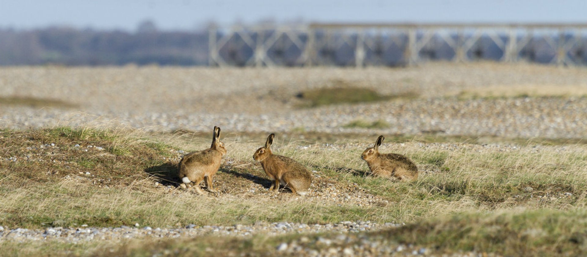
Orford Ness has diverted a river, formed an estuary, created over 10 miles of coastline and over 2,000 acres of land. From the visitor trails you can see the rich and varied habitats that have developed on this internationally significant nature reserve and former military testing site and the wildlife that makes its home here.
Grazing marsh on Orford Ness.
The grazing marshes on the Ness are flat and open with pools of water that expand and contract through the season providing habitat for breeding and migrant birds. Sheep graze to provide the varied grass height the birds prefer, eating around the military debris. The King's Marsh brackish lagoons provide an important habitat for invertebrates.
The river walls have stopped salt water from flooding the marshes on normal high tides. However, due to seepage and periodic flooding a residual salinity remains creating a sward composition in the pastures dominated by the rough grass sea couch (Elytrigia atherica) . Saltmarsh plants occur around the edges of the scrapes. Grazing and mowing aims to provide a variation in sward height that will encourage wading birds to breed within the open pasture areas.
Careful control of water levels combined now with alterations in the profile of the marshes to create wet scrapes and pools provides marginal feeding areas for breeding birds in the spring and summer, and in the autumn and winter larger flooded areas for passage and overwintering wildfowl. The pasture and the scrub areas around the buildings provide habitat for passerines, some of which (with marsh harrier and other species) also make use of the reed marsh found within the airfield site.
Brackish Lagoons.
Orford Ness contains one of the largest areas of unimproved brackish marsh in Suffolk. Brackish lagoons are an important habitat because they support a small but significant group of unusual plants and animals, as a result of the fluctuating salt content of the water.
Only very few species can tolerate the changing salt levels in these lagoons, and we have some nationally very rare species, such as the starlet sea anemone (Nematostella vectensis), a species within the UK BAP. The importance of this habitat is one reason why Orford Ness was designated as a Special Area for Conservation under European Union Directives.
In 2011 further work was done as part of the third EU-funded LIFE project on the Ness. Two new brackish lagoons were created in the Kings Marsh. The northernmost lagoon also links to Stony Ditch through an inlet sluice, and via a water control point to the network of creeks and ditches that control water levels within the marsh. By carefully using the sluice and controls, water levels can be better managed within the Kings Marsh, particularly to encourage avocet, common tern and other nesting birds to use the islands in the lagoons.
Coastal vegetated shingle.
In Suffolk there are 859ha of vegetated shingle, about 20 per cent of the national resource. Orford Ness is the largest vegetated shingle spit in Europe and the second largest but best preserved area of vegetated shingle in Britain at 570ha (Dungeness being the largest at over 2,000ha).
Colonisation of shingle is dependent on three main factors – degree of disturbance and mobility of shingle due to factors such as wave action; presence or absence of ‘fines’ in the shingle matrix; and the availability of moisture. Shingle ridges are formed by wave action (in particular storm waves) against a beach and as the shingle is laid down it is naturally sorted and graded by size, with the larger stones lying in the valleys and the smaller ones on top of the ridges.
The finer (less than 5mm) fraction on the ridge improves seed and water retention, and although not essential allows some organic debris to be trapped and held. The presence of the 'fines' is thus crucial to the germination, establishment and survival of shingle plants, which depend on this matrix of shingle, with finer material mixed in with coarser particles.
Coastal vegetated shingle habitats are extremely fragile; the damaging effects of access on foot, and particularly by vehicles, have degraded many areas on the Ness, with loss of vegetation. Military use of Orford Ness has now ceased, but walkers and fishermen can still access the beaches. Such disturbance by humans can also have detrimental effects on breeding, feeding and roosting bird populations, which also have to contend with ground predators and very high tides. For example ‘loose’ colonies of little tern are under severe pressure on Orford Ness from all these causes of disturbance.
Reed Marshes.
Reed-bed communities are relatively scarce on Orford Ness. In late 1997, under an EU LIFE-Nature project, one site was extended by 2 ha, from 0.4 to 2.4 ha. The area had been rank grassland with two small pockets of common reed (Phragmites communis) and sea club-rush (Scirpus maritimus) growing in some old 'borrow pits' (where clay had been dug for river wall defences).
The work involved scraping off between 30 and 80cm of clay from the surface of the site, with the intention of lowering ground levels to those of the base of these pits, to enable the reed rhizomes beneath the clay to produce productive shoots. This lowering also in effect enables water levels to be raised, which suits the reed. To compliment this, areas of deeper open water and islands were also created.
Since the work was completed the areas of reed have already expanded, and the new habitat is already benefiting, amongst others, marsh harrier (Circus aeruginosus), an Annex 1 species under the EU Birds Directive (79/409/EEC), and bearded tit (Panurus biarmicus), as well as many invertebrate species. Marsh harrier have bred and successfully raised broods on this site since 1999.
Stony Ditch.
Found on John Norden's map of 1600 and named Stone Eye, this tidal creek, which joins the River Ore about a mile downstream, is wide and shallow and at low tide an expanse of mud is exposed with only a tiny tidal channel.
** – Orford Ness Trails – **
After your welcome by an experienced ranger, follow the waymarked trails through the internationally rare and protected vegetated shingle, salt-marsh, mud-flats and brackish lagoons. See the wide range of birds and plants on the Ness. The red route is open on all open days but access to the blue and green routes is restricted to protect the wildlife during the breeding season.
Click here to download a map of the self guided trails.

** – Visiting – **
An Internationally important coastal nature reserve, with a fascinating 20th-century military history. Take a short boat trip to this wild and remote shingle spit, the largest in Europe. Follow trails through a stunning landscape and a history that will both delight and intrigue. Discover an internationally important nature reserve littered with debris and unusual, often forbidding, buildings from a sometimes disturbing past. Please note: charge for ferry over to the nature reserve (including members). Tickets are limited and sold on the day only so please arrive early to avoid disappointment.
** – Facilities – **
General
Family
Accessibility
Open 31 March- 23 June Saturdays only. 26th June - 29th September Tuesday - Saturday. 6th - 27th October Saturdays only. Access is by National Trust ferry from Orford Quay. Boats cross to the Ness every 20 minutes between 10am and 2pm only, returning regularly through the day; last ferry leaves the Ness at 5pm. Tickets are limited and sold on the day only so please arrive early to avoid disappointment, especially at busy times. Main visitor trail (Red Route) always available, other routes open seasonally.
Location : Orford Ness National Nature Reserve, Orford, Woodbridge, Suffolk
Transport: Wickham Market (National Rail) 8 miles OR Melton (National Rail) then bus. Bus routes: local service from Woodbridge (passing Melton train station). Bookable demand-responsive service 01728 635938. Ferry: only access to Ness via National Trust ferry Octavia.
Opening Times : See Above.
Tickets inc. ferry: Adults £10.00; Children £5.00; Members £4.00 and £2.00.
Tel: 01728 648024

