The Marsden Moor Estate is a large expanse of moorland in the South Pennines, between the conurbations of West Yorkshire and Greater Manchester in the north of England. It is named after the adjacent town of Marsden, and is owned and administered by the National Trust to whom it was conveyed in 1955 by the Radcliffe family in lieu of death duties.
The estate covers 2,429 ha (5,685 acres) of unenclosed common moorland and almost surrounds Marsden. Part of it is in the most northern section of the Peak District National Park. The landscape is made up of moorland, valleys, peaks and crags and has long been modified by man.
Marsden is at the eastern gateway to the important ancient Standedge crossing of the moors and evidence of transport related archaeological remains dating from pre-Roman times have been discovered close to the great engineering structures of the canal and railway ages. The moors have been a water catchment area since the Victorian era when several reservoirs were built, along with their associated catchwaters in the Wessenden Valley.
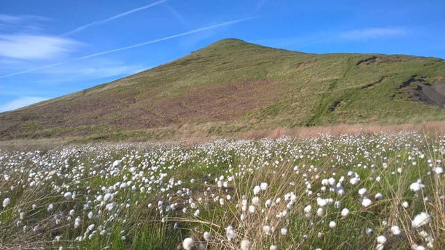
The landscape supports large numbers of moorland birds such as the golden plover, red grouse, curlew and twite. The estate, a designated Site of Special Scientific Interest, forms part of a Special Protection Area and is a candidate Special Area of Conservation.
The estate is managed from a base in the old goods yard, adjacent to Marsden railway station, and the old goods shed has been converted into a public exhibition, entitled Welcome to Marsden, which gives an overview of the estate and its history.
*** – Places – ***
Pule Hill.
From the top of Pule Hill, which is one of the highest points (437 metres/1434ft), there is an amazing 360 degree view across the moorland. Pule Hill quarry was mainly worked during the second part of the eighteenth century.
The quarry comprises a 20m face extending 100m along the western slopes of the hill. Hidden in the quarry is the Marsden Stanza Stone (Snow stone), engraved with a poem by local poet Simon Armitage and part of the Stanza Stone trail.
Buckstones.
From Buckstones car park (A640) there are magnificent views across the Upper Colne Valley to Pule Hill and beyond.
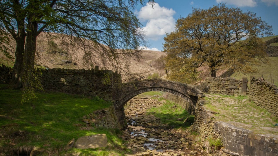
Eastergate Bridge.
This famous packhorse bridge, once used to transport wool from Huddersfield to Rochdale is now an ancient monument. Although named Close Gate Bridge on the Ordnance Survey maps it is known locally as Eastergate Bridge; perhaps because Esther Schofield kept the Packhorse Inn which stood here more than a century ago, and ‘Esther Gate’ became ‘Eastergate’.
The bridge crosses the River Colne near its source and this lovely place is ideal for a family picnic.
Wessenden Valley.
The Wessenden Valley, south of Marsden village centre, is dominated by a series of four reservoirs: Wessenden Head, Wessenden, Blakeley and Butterley, the last being the largest. It is a great place for a gentle stroll up or down the valley. Alternatively you can join the Pennine Way for a more challenging walk across the moors.
*** – Standedge circuit walk – ***
An exhilarating circular walk, a large part of it on the Pennine Way, exploring the varied landscapes of Marsden Moor. Discover valleys and reservoirs before heading over open moorland with far-reaching views before winding back to Marsden along the old packhorse route and Huddersfield narrow canal. Classified as Challenging, this walk is ten miles long and should take about five hours. This is a dog-friendly walk.
Start: Marsden train station.
1. From Marsden train station go down Station Road turning right to cross the bridge over the river and on to Church Lane. Just after the church, before the road bends towards the main road, take the small lane opposite at the side of 'The Cottage'. Follow this road through the tunnel under the A62 and turn right towards the roundabout with Marsden FC on the left. Go straight across at the roundabout to walk up Binn Road towards Butterley reservoir and spillway.
2. Turn right off Binn Road at Butterley spillway onto the wide track marked with a public bridleway sign. Follow this track up the Wessenden valley passing Butterley and Blakeley reservoirs in turn on your right.
3. At the Pennine Way fingerpost take a right to follow the Pennine Way downhill into the valley, across the footbridge and then up the steep slope in the other side.
4. At the top of the slope turn right to continue along the Pennine Way along Blakeley Clough crossing the brook to walk up the steps that lead on to the moor. Continue along the Pennine way, crossing open moorland, with far-reaching views on a clear day, until you reach Swellands and Black Moss reservoirs.
Moorland birds. Marsden Moor is protected at a national and European level because of the blanket bog habitat and the important breeding birds it supports. You may spot some of these birds on this walk, especially when crossing open moorland. Species to watch out for include curlew, golden plover, red grouse and the elusive twite.
5. On reaching Black Moss reservoir go across the small footbridge and continue along the dam wall. Follow the flagged path around to the left (with fence line on right hand side). Continue along the flagged path, go through a wooden kissing gate and head downhill and through another gate to continue down to the meet the Pennine bridleway.
6. At the junction with the Pennine Bridleway, with Redbrook reservoir straight ahead, turn left along the bridleway until you reach Brun Clough car park.
7. From the car park, cross over the road (A62) and follow the Pennine Way sign up the track ahead and turn left at the top. Continue until you reach the Pennine Way/Bridleway fingerpost and turn right through the kissing gate to follow the path uphill. Follow the Pennine Way north, passing through a field with kissing gates at either end. Be aware that livestock graze in this field. Continue along Millstone Edge taking in views across the moors and west towards Manchester.
8. At the stone waymarker, signed Oldham Way & Pennine Way, turn right to continue along Pennine Way with the fence line on your right hand side. Follow the path towards Haigh Gutter and the A640.
9. Just before reaching Haigh Gutter the road takes a sharp right across a ford and onto the footpath, this is the old Packhorse Road, which was constructed in the Middle Ages. Follow this path down and across the moorland with March Haigh reservoir and Buckstones to your left. At the fork with the Packhorse Road marker, continue downhill heading towards Easter Gate, taking in views of Pule Hill to your right.
10. When you reach the valley bottom cross Easter Gate bridge, also known as Close Gate bridge and follow the footpath along the side of the river Colne to the road. You can follow the red waymarkers ‘Easter Gate return’ back to Marsden. Turn right off Waters Road through the gate into tunnel end nature reserve. On reaching Standedge tunnel car park head right to cross over the canal and follow the towpath alongside Huddersfield narrow canal back to Marsden train station.
End: Marsden train station. You made it!
*** – heritage trail south – ***
Climb up above the Wessenden Valley on this challenging 8 mile circular walk. You'll be rewarded with views across the valley whilst learning about the history of this magnificent landscape. Whilst exploring the rugged scenery of Marsden Moor you may spot some of the moorland plants and birds that make this area internationally important. The weather can change very quickly across open moorland - so please come prepared!
Take a walk on the wild side. Classified as Moderate (tending to Challenging), this walk is eight miles long and should take about four and a half hours. This is a dog-friendly walk.
Start: Marsden Moor Estate Office, by train station.
1. From the estate office, head down Station Road through Marsden and cross the A62. Walk through the park, past the band stand to come out on Carrs Road. Cross the road and take the path at the end of the row of cottages. Follow the path past a newly-renovated house behind the other houses, keeping the wall on the left and then, after a short distance, turn right. Head uphill and over a stile until you arrive at a house and stables. Turn left, then go over another stile and follow the path behind the house. Keep right until you reach a choice of three gates. Take the left-hand gate to head up the slope, where you cross a stile which takes you onto a track. Turn left and head past Upper Acre Farm to meet the Deer Hill Conduit. Turn right and follow the conduit until you reach waymark number 9. Here you can take in the view of Marsden and its mills and appreciate how important the mills were to the local economy.
History. The moorland around you has been used for thousands of years, from hunter-gatherers ambushing prey to packhorse roads taking goods to market. You will walk past reservoirs and conduits supplying water to the people of Yorkshire, feeding the Huddersfield Narrow Canal.
2. Continue along the conduit to reach waymark number 10 and take in the fine views over the Butterley and Blakeley reservoirs. Keep walking along the conduit, crossing over a stile. Just before you get to the next stile, head down the field boundary to the corner stile and take the path behind Wessenden Lodge.
3. When you meet the main Wessenden track, turn right and follow the path in front of the Lodge and continue down this track for about 880yd (800m). Follow the Pennine Way steeply down into the bottom of the valley and then even more steeply back to the top to meet waypoint 11. Here is a good point to catch your breath and admire the views of the Wessenden Valley and former shooting lodge.
Birds. Marsden is host to an array of moorland species such as curlew, grouse, golden plover, dunlin, merlin, short-eared owl and even the rare twite.
4. Follow the Pennine Way to the right, along Blakely Clough and up steps onto the moor to reach the Black Moss and Swellands reservoirs. More information can be found on the interpretation panel here.
5. Cross the dam wall and follow the path left towards Black Moss other dam wall, then head right and follow the path northwards through one of the National Trust sheep enclosures. The area you are walking through was once very badly eroded, but by eliminating grazing and spreading heather brash and seeds the plot has recovered. Still vulnerable to wild fires, the plot was almost burnt in spring 2009. Keep walking along this path until you meet the Pennine Bridleway. Turn right and walk along the bridleway to meet Mount Road where you will find an information board about the turnpikes.
Plants. You may find common upland species such as heather, bilberry, crowberry and a variety of grasses and, if you are lucky, you might come across the carnivorous sundew.
6. If you fancy getting some stunning views of the estate from the top of Pule Hill, follow Mount Road left/westwards until you come to a signpost on your right pointing out the Standedge trail which contours around Pule Hill. This path is very boggy at the beginning but soon dries out. Continue around until you come to the path that leads you up past the quarries where you can turn back on yourself to walk along the edge to the summit and waypoint 14. Walk straight back down to join Mount Road and retrace your steps to the information board.
Moor restoration. The National Trust carries out important restoration work on Marsden Moor to help conserve it for the future. Work includes gully blocking using wooden dams and heather bales to keep the peat wet and stable and prevent it from being washed away. They also re-vegetate bare peat with cotton grass and heather to prevent erosion and provide food and shelter for birds. If you would like to help with the restoration of the moor or help with guided walks and community events contact the office on 01484 847016.
7. Carry on past the information board until just before the cattle grid where you turn left onto Old Mount Road and then follow the footpath along a track towards Hades Farm until you reach waymark number 15. The path leading off the track leads down to meet up with Old Mount Road where you turn left and head back down into Marsden. Cross the A62 again and walk past St Bartholomew's church to Station Road and back to the car park.
End: Station Road car park. You made it!
*** – Easter Gate return walk – ***
An easy, return walk following the red waymarkers along the canal towpath through winding quiet lanes before reaching the historic Easter Gate bridge. Classified as Easy, this walk is nearly three miles long and should take about one and a half hours. This is a dog-friendly walk.
Start: Old Goods Yard.
1. From the Old Goods Yard and National Trust Office follow the railway fence line to Marsden station and join the canal towpath at Lock 42E. The red waymarker arrows that mark the trail begin just outside the Marsden Moor office.
2. Follow the towpath until the Standedge Tunnel Visitor Centre is in view on the right and then bear left through a small, wooded picnic area.
3. Walk over the bridge, through the car park and bear left up the grassy bank.
4. Cross the lane and follow the well surfaced path along the river leading to a wheelchair friendly picnic area. Continue until you reach a wooden gate by the road.
5. Turn left along the road past a row of houses on your left and Hey Green on the right. Continue onto Blake Lea Lane which becomes Waters Road and bear left at Eastergate cottage onto the bridleway path.
6. Go through the gate and follow the path along the river until you reach the packhorse bridge called Easter Gate Bridge, also known as Close Gate Bridge.
7. To return follow the path over Easter Gate Bridge and along the riverside onto Blake Lea Lane.
8. Turn right on to Waters Road and retrace your steps through the nature trail alongside the river.
9. Walk over the lane and down the grassy bank towards the car park at Standedge Tunnel Visitor Centre.
10. Turn left to rejoin the towpath under the railway bridge.
11. After the bridge turn right and walk up the stone steps and bear left along the path through the woodland.
12. Walk through the gate at the end of the woodland and turn right to re-join the canal towpath back towards Marsden and the Old Goods Yard car park.
End: Old Goods Yard. You made it!
*** – Pule Hill walk – ***
A circular walk that starts along the canal towpath before gently contouring around the sides of Pule Hill. Enjoy views over the moorland and see the remains of Marsden's industrial heritage, as you pass the Engine House and ventilation shafts that extend down to the railway and canal tunnels below. Classified as Moderate, this walk is four and a half miles long and should take about two and a half hours. This is a dog-friendly walk.
Start: Marsden train station.
1. From Marsden train station walk west along the towpath, following the red waymarkers towards Standedge Tunnel visitor centre.
2. Cross the canal and walk through the carpark. Take a left up the grassy bank between the knee rail fencing - Standedge Tunnel visitor centre is on your right. At the gap in the wall turn left to walk along a walled track behind the Water's Edge restaurant. Cross over the bridge and canal again, following the walled track until it brings you out on Manchester Road (A62).
3. Turn right to walk along the A62. When you reach the Hey Green house on the right hand side cross over the road and go over the stile immediately opposite.
4. Follow the path uphill and to the right, running parallel to the road around Pule Hill. Continue along this path keeping close to the farm walls on your right, passing a wind turbine on the right. To your right is a lovely view across Marsden Moor. Continue for a while crossing a few small boardwalks. When you come to a stile in a wall cross the stile and continue straight ahead. Then cross a second stile to walk toward two brick ventilation shafts.
Industrial Heritage. Along the route you will pass by the Engine House and ventilation shafts, evidence of the areas industrial past. These ventilation shafts extend down to the railway and canal tunnels below, which link Huddersfield with Oldham and beyond.
5. Stay on this lower path heading towards the far ventilation shaft. Follow the path parallel to the electricity poles. Now follow a well-defined path until you walk across a boardwalk and out onto Mount Road.
Additional detours. Stanza Stone detour - A short detour up to Pule Hill Edge quarry to view the Stanza Stone. This is one of a series of water themed poems by local poet Simon Armitage which form the Ilkey Literature Festival Stanza Stone trail. Pule Hill view detour - Follow the path upwards toward the top of Pule Hill 1434ft - it is quite steep in places - for panoramic views across the moorland.
6. Turn left along the road to a junction just before the cattle grid.
7. At the junction turn left up Old Mount Road and then take the left fork up the stony track signposted Hades Farm. Continue along this track for about half a mile until you reach the Heritage Trail marker 'stone no.15'.
Wide ranging views. Step 7 is a great place to admire panoramic views over Marsden village and the bottom of the Wessenden Valley.
8. From here drop down the hill to the gate on the right and follow the walled path downhill. Follow the track round to the right, reach Old Mount Road at the bottom and then turn left to follow the road into Marsden. At the bottom of the road, cross over the A62 (Manchester Road) to walk down Towngate with St Bartholomew's church on the left. Turn left up Station Road, back to Marsden train station.
End: Marsden train station. You made it!
*** – Facilities – ***
General:-
• All parking is free: Buckstones Car Park - A640 (junction with B6114), Haigh Gutter – A640 (at Pennine Way crossing), Wessenden Head Layby – A635 (Greenfield to Holmfirth Road) Various laybys on the A640, A62 and A635. Marsden village Car Park (not National Trust), The Old Goods Yard, Station Road, Marsden, HD7 6DH (suitable for coaches).
• There are no public toilets in the area.
• Ice cream vendor at Buckstones Car Park (summer only).
• Marsden Moor information room is next to the National Trust office, (adjacent to Marsden train station).
• Dogs are welcome but must be kept on a lead during nesting season (1 March-31 July).
• Marsden Moor is well served by public footpaths with over 100 miles crossing the moors. Pick up a leaflet from the information room or download from the NT website.
• Buckstones Car Park offers fantastic views across the moors.
Family:-
• Eastergate is a great place for a picnic - children can play in the river and enjoy the countryside.
• Buckstones car park offers amazing panoramic views over the moorland. There is an ice-cream vendor on summer weekends.
Access:-
• The general topography of the landscape and conditions of the footpaths (which can be muddy) means the moorland is not considered suitable for people with limited mobility.
• There are no designated accessible spaces at Buckstones car park but the surface is tarmacked and level.
• The other car parks and laybys are relatively level with a top layer of loose gravel.
• Level access (no obstructions) to the Information Room, next to Marsden NT office.
Location : Marsden Moor Office, The Old Goods Yard, Station Road, Marsden, West Yorkshire, HD7 6DH
Transport: Marsden (National Rail) 2 minutes. Bus Routes : 183 – 184 from Huddersfield to Marsden, and 184 from Manchester/Oldham to Huddersfield stop outside.
Opening Times Countryside: Dawn till Dusk
Opening Times Information Room: Weekdays - 08:30 to 16:30; Weekends 09:00 to 17:00
Tickets : Free.
Tel: 01484 847016