
Spectacular cliffs, caves where mammoths once lived, rare birds, an underground river, bat roosts, silver lead mining, ancient woodland, smuggling and limestone quarrying are just a few of the wonders of this area. There are also numerous archaeological features and two important caves – Bacon Hole and Minchin Hole. Long Ash Mine in Bishopston Valley was a silver lead mine and is now a roost for greater and lesser horseshoe bats.
Pwll Du Bay was once an extensive limestone quarry. The buildings that remain were once inns for the thirsty workers. The bay was also a popular smuggling cove with some of the contraband maybe being sold in the inns. Pwll Du Head is the highest headland on Gower and offers fantastic views of Pennard Cliffs and the coastline towards Mumbles.
Pennard Castle is a ruined castle, near the modern village of Pennard on the Gower Peninsula, in south Wales. The castle was built in the early 12th century as a timber ringwork following the Norman invasion of Wales. The walls were rebuilt in stone by the Braose family at the turn of the 13th and 14th centuries, including a stone gatehouse. Soon afterwards, however, encroaching sand dunes caused the site to be abandoned and it fell into ruin. Restoration work was carried out during the course of the 20th century and the remains of the castle are now protected under UK law as a Grade II* listed building.
The Normans began to make incursions into South Wales from the late-1060s onwards, pushing westwards from their bases in recently occupied England. Their advance was marked by the construction of castles and the creation of regional lordships. Pennard Castle was built at the start of the 12th century after Henry de Beaumont, the Earl of Warwick, conquered the Gower Peninsula and made Pennard one of his demesne manors.
The castle was constructed on a limestone spur, overlooking the mouth of the Pennard Pill stream and Three Cliffs Bay, and was protected to the north and west by surrounding cliffs. The fortification initially took the form of an oval-shaped ringwork, 34 by 28 metres (112 by 92 feet), with a defensive ditch and ramparts around the outside, and a timber hall in the centre. A local church, St Mary's, was built just to the east and a settlement grew up around the site; a rabbit warren was established in the nearby sand dunes. In the early 13th century, a simple stone hall, approximately 18.6 by 7.6 metres (61 by 25 feet), was built on the site of the older timber building, using red-purple sandstone with white limestone detailing.
Around the turn of the 13th and 14th centuries, while the castle was controlled by William and his son, also called William, the timber defences were replaced. A thin stone curtain wall, approximately 8 metres (26 feet) tall with battlements, replaced the palisades, with the mural defences including a square tower on a rocky spur on the west side, and a circular tower on the north-west corner. A gatehouse was built as the new entrance, with two half-circular towers that possibly imitated those of regional castles such as Caerphilly; it was weakly defended by a portcullis and a handful of arrow loops. The new walls were built from a mixture of red sandstone rubble, probably quarried locally, and limestone dug from the castle site itself. The Braoses may have rebuilt Pennard as a replacement for their castle at nearby Penmaen which was abandoned at around the same time due to encroaching sand dunes.
Pennard Castle also began to suffer from sand dune encroachment and the castle and its settlement were gradually abandoned. A survey in 1650 described the fortification as being "desolate and ruinous" and surrounded by sand. By 1741, the castle's south wall had mostly collapsed but the remainder of the castle was apparently still generally intact, although it had suffered further losses by 1795. It was a popular subject for engravings, sketches and paintings from the 18th century onwards, with the view of the ruins from the east proving particularly popular. By 1879, large cracks had appeared in the southern tower of the gatehouse, which led to its partial collapse.
By 1922, concerns had grown about the condition of the castle and discussions took place between the Penard Golf Club, who owned the site, the Royal Institution and the Cambrian Archaeological Association. A joint committee was formed to raise the funds for repairs to the stonework but the costs appear to have been excessive and instead the gatehouse was patched with concrete between 1923 and 1924. Much of the remaining southern wall collapsed at the beginning of 1960 and an archaeological survey was conducted between 1960 and 1961. Urgent masonry repairs were then carried out in 1963, paid for by a combination of the Ministry of Public Buildings and Works, the Gower Society, the golf club and a public appeal launched by local newspapers.
In the 21st century, the ruins of the gatehouse still survive, reaching up to the battlements on its east side, partially because it was built with very strong mortar. Parts of the curtain wall survive, mainly on the north and east sides, now around 1.1 metres (3 feet 7 inches) thick and averaging 5 metres (16 feet) tall, along with the remains of the square mural tower.
The parish church of Pennard, St Mary's, post dates an earlier medieval church of the same name near to Pennard Castle. The older church was abandoned in the 1500s and only the foundations remain. The newer church was restored in 1847 and a porch added. Inside the church there is a Jacobean pulpit and font cover, as well as some 18th-century wall tablets. The church became Grade II listed in 1964. The poets Vernon Watkins (1906–1967), Harri Webb (1920–1994) and Nigel Jenkins (1949–2014) are buried in the churchyard.

Enjoy spectacular views over Gower and South Pembrokeshire, and picnic on one of Gower's most iconic beaches, with a view of Pennard Castle ruins which could be taken straight from a Hollywood movie. The walk is rated as Moderate, will take about 30 minutes and is approximately one mile long. It is a dog-friendly walk.
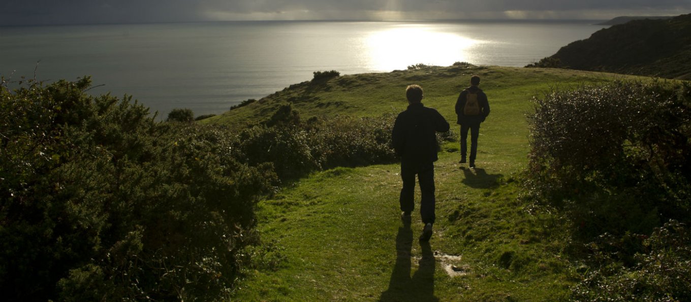
Start at Southgate car park. From the car park bear right and follow the path as it winds its way along the coastal slope. Look out for the limestone soil loving flowers that make a wonderful display in spring. Look out for flowers such as thrift and spring squill that love the limestone rich soil.
Continue along the coast as you leave the houses of West Cliff behind you until you gradually begin to go downhill. You will gradually descend into the sand area of the dunes of Three Cliffs Bay. Lizards bask on the hot sand during the summer and can often be seen scampering away as you approach.
Continue down until you reach the bottom and enjoy your picnic! If you fancy a further stroll then continue to the river and cross the stepping stones. Stepping Stones - Here you'll find a fantastic view of Pennard Castle along the river valley. Finish at Three Cliffs Bay.
The Terrain. Follows the coastal footpath, with a downhill section to the bay, so you may want to take it easy on the way back up. Dogs are welcome, but please keep on leads as livestock are present.A walk through a wooded valley, including muddy woodland floors and an uneven stony path. The walk starts with a steep descent into the valley and ends by climbing back up the same hill. The beach at the halfway point has a pebble ridge.
Parking in Southgate Car Park (NT): fee payable, NT members free; or street parking. Assistance dogs are welcome. There are toilets in Southgate. Shop and coffee shop in Southgate. The paths on Pennard Cliffs suitable for pushchairs. Some paths on Pennard Cliffs suitable for wheelchairs. There is Disabled parking at Southgate Car Park (NT).
The coastline along this stretch of the South Gower coast is particularly important for the plants that flourish in the limestone grassland. One flower to look out for in particular is yellow whitlow grass, which only grows here.
Again classified as Moderate this is considerably longer walk than above. Four miles long and classified as dog friendly, this walk will take about two hours.
Start at Southgate car park, grid ref: SS554874. Start with the National Trust car park hut on your right and walk along the track for about a mile (1.6km). On a clear day there are spectacular views across the Bristol Channel to Somerset and Devon. The coastline along this stretch of the South Gower coast is particularly important for the plants that flourish in the limestone grassland. One flower to look out for in particular is yellow whitlow grass; this is the only place it grows in the UK.
When you reach Hunts Farm fork right onto the coast path, signed Pwll Du Head, which will go up some steps with a wall on your left. Hunts Bay has large rock formations and shingle but used to be covered in sand. When you pass a small pond on your left look for the path which bears right and go uphill with a fence on the left. When you reach the top, look out for the banks and ditches - all that remain of an Iron Age promontory fort. High Pennard is one of a series of Iron Age promontory forts irregularly spaced along the South Gower coast. Pottery dating to the first or second century AD has been found here.
Continue along the coast path, following the route through the gorse and around the headland. Pwll du Bay. The sheltered bay was once a favoured location for smugglers, as they'd quickly disappear up into the wooded valley and out of site. The bay was also a limestone quarry until 1902, exporting limestone to north Devon. You are now standing above a cliff known as Graves End, so named as it's near the spot where the ship the 'Caesar' was wrecked in 1760. The 'Caesar' was a Naval vessel charged with 'press ganging' unfortunate and unsuspecting individuals into recruiting as part of the Royal Navy. When the Caesar went down, the majority of its unwilling crew were locked below deck and perished on the rocks. They were buried in a mass grave at Graves End. Finish back at Southgate car park.
The terrain. Varied terrain from clifftop paths and stony tracks to woodland paths (often muddy). Some of the route (particularly on the coast) can be steep. There are stiles and steps. Dogs are welcome but please be aware that livestock graze the area all year round. Parking in Southgate Car Park (NT): fee payable, NT members free; or street parking. Assistance dogs are welcome. There are toilets in Southgate. Shop and coffee shop in Southgate. The paths on Pennard Cliffs suitable for pushchairs. Some paths on Pennard Cliffs suitable for wheelchairs. There is Disabled parking at Southgate Car Park (NT).
A challenging walk through a hidden valley. Discover a secret world of limestone caves, underground rivers and ancient woodland and emerge from beneath the canopy onto one of Gower's most beautiful, but secluded beaches. This walk will take even longer, about two and a half hours , so pack some sustenance. Rated as Moderate, this is a dog friendly walk of approximately four miles.
Starting at Kittle Green, walk past the National Trust sign and keeping Great Kittle farm on your right follow the footpath into the trees. The path drops down the slope for about 0.25 miles (0.4km) and can be slippery after rain. When you reach a fork in the path bare left and go down the steps until you reach the chestnut fence on your right. The enormous hole in the ground is called Daw Pit. This hole was formed where the underground river caused the land to collapse.
Continue down the steep slope to the bottom and turn right along the dry river bed. Cross the river to walk on the left hand side, taking care of the uneven surface for about 200yds (180m). The track crosses back across the river at this point. During wet periods the river will be running here but is usually shallow and easily crossed. Bishopston Valley. The stream is sometimes seen to disappear into holes called 'sinks' and re-emerge halfway down the valley to run above ground. The track here is usually muddy. Keep listening for the sound of the river as you get closer to Guzzle Hole.
Guzzle Hole is a cave from the outside of which you can hear water thundering in the underground stream, often making unusual sounds, hence the name 'guzzle'. Long ash mine can be seen on your left. The mine produced both silver and lead and was in service until 1854. The grille is in place to protect the roosts of greater and lesser horseshoe bats. There are also remains of old miners' cottages nearby. Cross the river again and go up some steps, keeping left as you do.
You will soon come across one of three bridges that cross the river along the valley. The valley was once a busy place providing food, fuel and work for many surrounding villages and many small footpaths still link communities to the wood. Do not cross the bridge but continue on the path alongside the river. Look out for the old stone walls on your right as you continue, remnants from when the valley was grazed and there were much less trees than there are now.
Follow the path into the meadow in front of you. The wet meadows in the valley are registered as common land. The meadows are grazed by cattle and are home to a number of wildflowers. Follow the path as it heads back out of the meadow and resumes its place alongside the river. Soon you will reach another bridge, do not cross but continue along the path until you reach a fork in the path.
At the fork, keep left. Soon you will come to a right turn in the path, continue straight ahead keeping the river alongside the path following the sign to Pwll Du Bay. The sheltered bay was once a favoured location for smugglers as they would quickly disappear up into the wooded valley and out of site. The bay was also a limestone quarry until 1902, exporting limestone to north Devon. Go past the fence on the edge of the path and where it forks follow the path left down the hill. Do not cross the bridge. When you reach the private garden turn left and walk onto the beach.
The Terrain. A walk through a wooded valley, including muddy woodland floors and an uneven stony path. The walk starts with a steep descent into the valley and ends by climbing back up the same hill. The beach at the halfway point has a pebble ridge. Dogs are welcome.
There are Tea-rooms with both indoor and courtyard seating. The shop offers a range of gifts as well as seasonal plant sales. Take home your own pick from the walled garden's organic produce. There is onsite parking. Dogs are allowed in the gardens, however they do ask that they are kept on a short lead at all times.
There is a children’s play area located next to the café and shop. They do not allow bikes, trikes, skateboards, scooters or roller skates into the garden for safety reasons. Baby-changing facilities are available.
The majority of the gardens are wheelchair friendly. Disabled toilets are available. The East Lodge meeting room is unsuitable for wheelchair access. Courtesy wheelchairs are available to hire. Please call in advance to book. One electric car charging port is available in the main visitor car park. It has a 32 amp charge (full charge time approx. 8 hours). Assistance dogs are welcome.
Location : South Gower Coast
Transport : Swansea (National Rail) then bus (6 miles). Bus Routes : Gower Explorer 118 and 119 stop 2 minutes.
Transport Southgate Car Park: Bus Routes Gower Explorer, 14, 14a and 114.
Opening Times : Dawn to Dusk
Tickets : Free.
Tel. : 01792 390636

