
The embodiment of history, Plas yn Rhiw is an early 17th-century manor house in Y Rhiw, Gwynedd in northwestern Wales. The estate consists of a small house of Tudor/Georgian style, a garden of just under one acre in size, and many wooded acres. Located at the base of Mynydd Rhiw, the estate overlooks the beach of Porth Neigwl (Hells Mouth), Cardigan Bay, and the Llyn Peninsula.
The history of the manor's estate predates construction of the house to some 4000 years of the neolithic period. After the house's construction in the early 17th century (an inscription of I.L. on a window lintel is dated 1634), the manor house witnessed many historical family saga, which finally ended in the 1940s when the three sisters donated it to the National Trust in memory of their parents, Constance and William Keating. Before that, they had refurbished the garden and restored the manor house to its old glory. The three sisters, who lived in the house until each of their deaths, are buried in a church yard near Porth Ysgo, about 5 kilometres (3.1 mi) from their Plas yn Rhiw. Plas yn Rhiw is the only organic National Trust garden in Wales. The original garden was expanded by the trust to include 150 acres (61 ha) of surrounding woodland.
The family history of the owners of the Plas yn Rhiw is traced to tribes of some 4000 years old neolithic period, who lived in its close vicinity. Celtic forts within 2 kilometres (1.2 miles) of the manor house, of Middle Europe vintage, also testify to settlements of some 2000 years ago. Roman legionaries were stationed at Segontium (an outpost of the XXth Legion) near Caernarfon and their defence structures are corroborated by evidences near the 6th-century church of St Hywyn at Aberdaron.
The location also witnessed intermarriage and family squabbles among the descendants of the Neolithic people, immigrants from Ireland and the Iberian Peninsula who had made their living here. The offspring of this generation of people are stated to be the modern Welsh families living in this area.
The Gwynedd Royal Dynasty had been established here around the 5th century after defeating the Irish settlers. In the 9th and 10th centuries, local inhabitants faced many invasions by the Vikings and many churches were destroyed. However, the Gwynedd kings vanquished many of the Viking invaders and also the Saxons (the English people). Rhodri the Great, the first king of all Wales, ruled in the 9th century, and his great grandson, Meirion Goch, is reported to have built a house close to the present manor house of Plas yn Rhiw.
A conceptual version of the Plas yn Rhiw manor house has been interpreted as a 15th-century house having been built with 1 metre (3 foot 3 inch) thick stone walls and mud floors, covered with meadowsweet, found locally. Small, unglazed, sliced windows were covered with waxed cloth. There was a heavy main front door. Also conjectured were a main room with a circular staircase leading to a watch tower. A fireplace with chimney led to the thatched roof . The house was surrounded by the common setting of a farmhouse with pigsties, barns stables and houses for farm labourers.
A 16th-century "The Caernarfon Quarter Sessions Calendar" makes mention of the manor house as "Plas yn Rhiw" in the village of Rhiw. The residents of the manor house lived as respected gentry of the town, also participating in jury duty in the judicial system of the town. However, at that time, they did not have a traditional surname but were known by their father’s name. They eventually adopted the surname as Lewis, either suffixed or prefixed to their maiden name, for another 250 years and they were prosperous in the Welsh land.
The house originally built by Meirion Goch in the 10th century to prevent incursions by Vikings into Porth Neigwl was rebuilt. A French window in the present house, which was remodelled in 1820, has an inscription dated 1634 and attributed to John Lewis, presumed to be the owner of the house at that time. His son, Richard Lewis, was married to Rector Richard Glynn's daughter. The hierarchy that followed consisted of two sons of Richard Lewis, the second son inheriting the property after his father's death, who lived with his wife Jane in the house. They had a daughter, also named Jane, who married William William and they had a son who was also named William William who was married to Mary Jones, the daughter of the Rector of Llaniestyn. They had only a daughter named Jane Ann who became the sole heiress of the property, in 1816. She married an army gentleman by the name of Lewis Moore Bennet. It was during this time that the house underwent further expansion.
The Bennet's only child was also a daughter who became an heiress and married a very ambitious attorney, Cyril Williams, who was the son of the Rector of Llanbedrog. They had a son but the mother died soon after child birth. In 1846, Cyril Williams became the Mayor of Pwllheli but his ambitious plans to develop the place and to build a railway line from Worcester to Porth Dinllaen via Ludlow, Tremadog and Pwllheli, and then linking it to a ferry service to Ireland, did not come to fruition as he could not muster enough support for his plans in the House of Commons.
Cyril Williams remarried and had many children. His daughter, Anne Elizabeth Williams, had in fact inscribed her name on a diamond ring and placed it on glass in one of the rooms on the first floor of the house, which is closed now. After Cyril William's death in 1859, his son William Lewis Williams, an army officer, inherited the property but he died a bachelor, and the house, along with the estate, was sold for £8,000.
The property was purchased by Thomas Edward Roberts of Hendre, Aberdaron who lived in the manor house with his wife and children. But his son did not have any interest in living in the house as he was residing in Harlech. He, therefore, released the house and the land to Lady Strickland of Sizergh Castle and Garden, Cumbria, who lived in the manor house for two summers. She was instrumental in fixing a modern bathtub in the house; it is now a water display item in the garden. After her, one of the daughter's of Williams lived in the house for some time and then moved to Abergele in 1922. Then the house was deserted and remained untended till the Keating sisters bought it who, as children, had moved with their mother to Rhiw in 1904 and taken residence in a rented house.
In 1939, the Keating sisters, Eileen, Lorna and Honora, along with their mother, Constance, who traced their ancestry to the original owners of the manor, purchased the manor house. They embarked on a serious refurbishing process in which they improved the garden setting, acquiring more land to enhance the environmental setting of the house and brought back the old glory of the manor.
The Keating sisters’ personality shines through the whole house, it’s as if they never left. The library clearly reflects the interests of the Keating sisters in literature. Works housed in the George III bureau bookcase include the writings of Sir Clough Williams-Ellis and poetry figures such as R.S.Thomas and Teresa Hooley. Beyond the library is the sitting room where again the furniture represents the sisters’ taste. The finest piece of furniture here is the Dutch Mahogany and marquetry cabinets.
It was around the time of the Second World War when the sisters moved into Plas yn Rhiw. In the yellow bedroom next to the sitting room there are certain elements that reflect this time period. On the bed is a patchwork quilt; it’s one of the hundreds of thousands of quilts made by the people in Canada during the Second World War. They were sent to Britain by the Canadian Red Cross Society and given to bombed out families, hospitals and soldiers.
In 1939 Honora travelled on a cargo ship to the Far East. The 3 weeks she spent in Japan gave her time to study oriental techniques in painting and wood engraving. This is reflected by her collection of Japanese woodcuts, including one by Hokusai. Honora’s eye for art can be seen throughout the house, from her sketchbook on display in the parlour, to her printed woodcut of Llŷn printed for the Council for Preservation of Rural Wales and past exhibits from her time at Slade School of Art in London.
In the Keating sisters younger days they lived in Nottingham and London, where fashion at the time included the broad shoulder look (padded), puffed sleeves, fur coats, hats and florals. The Keating’s had an eye for fashion; they all had a fur coat each. The sisters had plenty to show from that era in their wardrobes; and we’re lucky to still have them in one piece. In all of the sisters’ rooms you’ll see their collections of fur coats hanging up, along with elegant gloves and hats placed on the beds. In Honora’s wardrobe are a range of dresses, in various colours, some with gold thread embroidery and fine pleating. They are almost wearable today.
The walls, measuring a depth of 6.5 feet (2.0 m) in places, were constructed of large stones. A third storey was built as an extension to the old manor house built in the 17th century. A stair-wing was added to the rear. It was extended laterally, also. The front elevation, as well as the doors and windows were redesigned with a Georgian façade. Sixteen pane, sash windows, and an above ground floor verandah were added. There is a stone, spiral staircase. The house was restored by the Keating sisters in 1939, with advice from Clough Williams-Ellis, which included removal of the ca. 1816 Regency style stucco to reveal the original grey stone walls.
Located on the grounds, and adjoining the manor home, a two storey former gardener's cottage is available for rent. It has its own kitchen, sitting/dining room, fireplace, bedrooms, and a bathroom.
There are several Grade II listed buildings on the estate, such as the cartshed which was listed in 1971, including the manor house and the detached cottage. There is also a summerhouse and a tool shed. An old mill next to a stream was granted Royal permission to grind its own corn.
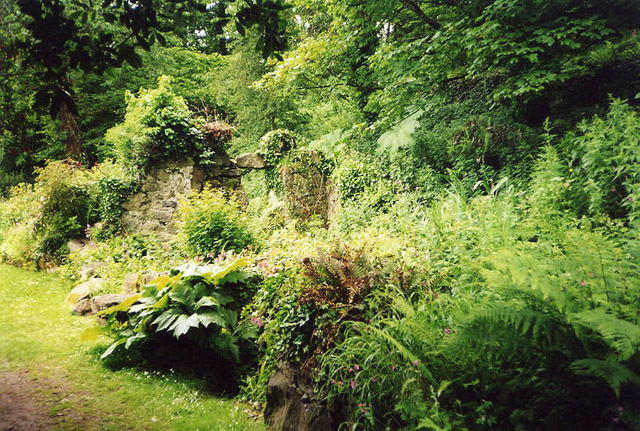
Set away from prevailing winds and benefiting from the microclimate, the garden lies below the house and is terraced into the slope, divided by hedges into several small compartments. There are native and cultivated plants in the garden. In spring and summer, there are displays of snowdrops and bluebells. Rhododendrons, azaleas, and magnolias are also part of the garden setting. The garden is accessible via grass paths and cobbled paths. Stone gateposts and seats, as well as old, unused buildings, and parterres are included in the landscaping. The parterre is referred to as Lady Strickland’s Garden. A slate plaque is situated outside the entrance to the garden and contains an epitaph.
The earliest known planting plan was developed in 1966 by Mildred Eldridge, an artist and the wife of poet R. S. Thomas. This was followed in 1994 when an improved plan was drawn by the garden designer John Hubbard.
Tim Walker, head gardener of the manor garden, boasts: "It's the only organic National Trust garden in Wales, and one of only three throughout England and Wales – although the other two, Trengwainton, near Penzance, and Snowshill Manor, in Gloucestershire, haven't got the same pedigree as Plas".
After the manor house, gardens and over 400 acres of countryside were given to the National Trust, the Trust added 150 acres (61 ha) of surrounding woodland that includes a Snowdrop Wood (Oxalis magellanica).
Grounds - partly accessible, some steep slopes, some steps and uneven paths. There is an adapted toilet at the shop / Visitor Welcome. There is a drop-off point. Building - level entrance. One step from main entrance to the hall.
Assistance dogs are welcome, other dogs should be on leads and only on the woodland walk below the car park. Enjoy a light lunch or afternoon snack at the tea-room.
Location : Rhiw, Pwllheli, Gwynedd, LL53 8AB
Transport : Pwllheli (National Rail) then Bus. Bus Routes : 17 or 18 from Pwllheli stops outside.
Opening Times : Wednesday to Monday 11:00 to 16:00; House 12:00 to 16:00.
Tickets : Adults £5.20; Children £2.60
Tel : 01758780219

Porth Meudwy is a small cove at the tip of the Llŷn Peninsula that was once the embarkation point for pilgrims making the journey to Bardsey Island. It was said that three pilgrimages to Bardsey equalled one to Rome. Today it still serves as the departure point for your visit to the island and as a small port for the handful of local fishermen who make their living catching crab and lobster in the waters around Aberdaron. In summer the fishing boats are joined in the cove by traditional sailing boats - built using designs unique to the Llyn - for the annual regatta.
Either side of the cove the spectacular Llyn Coastal Path winds its way along the tops of the coastal cliffs offering amazing views in every direction. A wealth of seabirds, acrobatic chough, bobbing seals and colourful heathland plants as well as an abundance of historical features, such as an abandoned quarry, along this stretch of coastline make for an interesting walk any time of year. The sights and sounds (and smells) of the fishermen bringing in their catch; amazing coastal scenery and the chance to spot wildlife such as chough and dolphins from the coastal path; a taste of local Aberdaron crab bought fresh from one of the shops, pubs or cafés in Aberdaron; a trip to Ynys Enlli, the island of the saints and home to an amazing array of wildlife
Bardsey Island (Welsh: Ynys Enlli), known as the legendary "Island of 20,000 Saints", lies 1.9 miles (3.1 km) off the Llŷn Peninsula in the Welsh county of Gwynedd. The Welsh name means "The Island in the Currents", although its English name refers to the "Island of the Bards", or possibly the island of the Viking chieftain, "Barda".
Bardsey is 0.6 miles (1.0 km) wide, 1.0 mile (1.6 km) long and 179 hectares (440 acres; 0.69 sq mi) in area. The north east rises steeply from the sea to a height of 548 feet (167 m) at Mynydd Enlli, which is a Marilyn, while the western plain is low and relatively flat cultivated farmland. To the south the island narrows to an isthmus, connecting to a peninsula on which the lighthouse stands. Since 1974 it has been included in the community of Aberdaron. It is the fourth largest offshore island in Wales.
The island was inhabited in Neolithic times, and traces of hut circles remain. During the 5th century, the island became a refuge for persecuted Christians, and a small monastery existed. Around 516, Saint Einion, king of Llyn, invited the Breton Saint Cadfan to move to the island from his first residence in Tywyn. Under Cadfan's guidance, St Mary's Abbey was built. For centuries, the island was important as "the holy place of burial for all the bravest and best in the land".
Bards called it "the land of indulgences, absolution and pardon, the road to Heaven, and the gate to Paradise", and in medieval times three pilgrimages to Bardsey were considered to be of equivalent benefit to the soul as one to Rome. In 1188, the abbey was still a local institution but, by 1212, it belonged to the Canons Regular. Many people still walk the journey to Aberdaron and Uwchmynydd each year in the footsteps of the saints, although today only ruins of the old abbey's 13th century bell tower remain. A Celtic cross amidst the ruins commemorates the 20,000 saints reputed to be buried on the island.
Saint Einion is sometimes claimed to have joined the community on the island, although his relics are claimed by Llanengan on the mainland. Saint Deiniol, the Bishop of Bangor, was buried on the island in 584. Saint Dyfrig was also buried on Bardsey Island, although in 1120 his remains were transferred to Llandaff.
The Dissolution of the Lesser Monasteries Act of 1536, on the orders of Henry VIII, resulted in St Mary's Abbey being dissolved and its buildings demolished in 1537. The choir stalls, two screens and the bells were transferred to Llanengan, where the parish church was then being built.
For many years Bardsey Island formed part of the Newborough Estate, and between 1870 and 1875 the island's farms were rebuilt; a small limestone quarry was opened, and a lime kiln constructed. Carreg and Plas Bach are separate buildings, but the remaining eight were built as semi-detached houses, each pair with outbuildings set around a shared yard. The buildings are Grade II listed and, in 2008, Cadw approved a grant of £15,000 to cover the first phase of repairs. Only one of the original croglofft cottages, Carreg Bach, survives. Given the choice of a harbour or a new church, in 1875 the islanders asked the estate to provide a place of worship; a Methodist chapel was built.
The island had a population of 132 in 1881; by 1961 it had fallen to seventeen. The island's small school, opened in a former chapel in 1919, closed in 1953; and by 2003 the population was down to four.
The Bardsey Island Trust bought the island in 1979, after an appeal supported by the Church in Wales and many Welsh academics and public figures. The trust is financed through membership subscriptions, grants and donations, and is dedicated to protecting the wildlife, buildings and archaeological sites of the island; promoting its artistic and cultural life; and encouraging people to visit as a place of natural beauty and pilgrimage. When, in 2000, the trust advertised for a tenant for the 440 acres (180 ha) sheep farm on the island, they had 1,100 applications. The tenancy is now held by the Royal Society for the Protection of Birds; and the land is managed to maintain the natural habitat. Oats, turnips and swedes are grown; goats, ducks, geese and chickens kept; and there is a mixed flock of sheep and Welsh black cattle.
A gnarled and twisted apple tree, discovered by Ian Sturrock growing by the side of Plas Bach, is believed to be the only survivor of an orchard that was tended by the monks who lived there a thousand years ago. In 1998, experts on the varieties of British apples at the National Fruit Collection in Brogdale stated that they believed this tree was the only example of a previously unrecorded cultivar, the Bardsey Apple (Welsh: Afal Enlli). The cultivar has since been propagated by grafting and is available commercially. Since its discovery it has led to a resurgence in many other Welsh Apples being discovered and propagated.
Bardsey Lighthouse stands on the southerly tip of the island and guides vessels passing through St George's Channel and the Irish Sea. It was built in 1821 by Joseph Nelson. Unusually for a British lighthouse it is square in section and is painted in red and white bands. Y Storws, sometimes referred to as The Boathouse, was built a few years before the lighthouse, near to the landing place at Y Cafn.
The island was declared a National Nature Reserve in 1986, and is part of Glannau Aberdaron ac Ynys Enlli Special Protection Area. It is now a favourite bird-watching location, on the migration routes of thousands of birds. Bardsey Bird and Field Observatory, founded in 1953, catches and rings birds to understand their migration patterns.
The island was designated a Site of Special Scientific Interest for its maritime communities; internationally rare lichens; bryophyte, vascular plant and bird species; and intertidal communities. Nationally important flowering plants include sharp rush, rock sea lavender, small adder's tongue and western clover, and the rare purple loosestrife is found in places. Two nationally rare heathland lichens are found on the slopes of Mynydd Enlli: the ciliate strap lichen and golden hair lichen; and there are over 350 lichen species in total. The leafcutter bee, named after its habit of cutting neat, rounded circles in rose leaves, used to seal the entrance to its nest, is native.
Thousands of birds pass through each year on their way to their breeding or wintering grounds. Chiffchaffs, goldcrests and wheatears are usually the first to pass through, followed by sedge warblers and willow warblers, whitethroats and spotted flycatchers.
About thirty species of bird regularly nest on the island, including ravens, little owls, oystercatchers and the rare chough. Hundreds of seabirds, including razorbills, guillemots, fulmars and kittiwakes, spend the summer nesting on the island's eastern cliffs, the numbers reflecting the fact that there are no land predators such as rats or foxes to worry about. On a dark moonless night an eerie cackling can be heard across the island as 16,000 pairs of Manx shearwaters, 5 per cent of the British population, come ashore to lay and incubate their eggs in abandoned rabbit warrens or newly dug burrows.
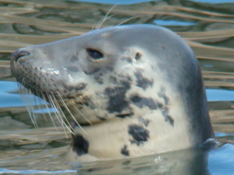
The island is one of the best places in Gwynedd to see grey seals. In mid-summer over two hundred can be seen, sunbathing on the rocks or bobbing in the sea, and about fifteen pups are born each autumn. Their sharp teeth and strong jaws are perfect for breaking the shells of lobsters and crabs which dwell in the waters. It is also possible to spot bottlenose and Risso's dolphins, and porpoises. The currents around the island are responsible for flushing in food-rich waters, and the Whale and Dolphin Conservation Society has been carrying out surveys since 1999 to find out which areas are particularly important for feeding and nursing calves.
The seas around the island are rich in marine life. There are forests of strap seaweed; in the rock pools are sea anemones, crabs and small fish; and in deeper waters, the rocks are covered by sponges and sea squirts. The yellow star anemone, found offshore, is more common to the Mediterranean.
Location : Nant, Bardsey Island, Pwllheli LL53 8DE
Transport : Pwllheli (National Rail) then Bus. Bus Routes : 17 or 17B from Pwllheli then ferry to Bardsey Island with Bardsey Boat Trips.
Opening Times : Dawn to dusk.
Free
Tel : 01758780219

Nestled in the heart of Aberdaron, Porth y Swnt is a visitor centre like no other. It offers an introduction to the history and culture of Llŷn through audio, videos, sculptures and artwork. Situated on the edge of Wales in the postcard fishing village of Aberdaron, Porth y Swnt is a gateway for discovering Llŷn - 30 miles of a dramatic, windswept and inspiring peninsula extending into the Irish Sea.
The name Porth y Swnt translates as gateway to the sound, which describes the centre as a doorway to discovering and exploring the surrounding area. The creation of local architect Huw Meredydd Owen, Porth y Swnt's aim is to encourage people to see Llŷn in a new light through the ground-breaking interpretation which encourages people to rediscover the vast beauty of the Llŷn peninsula.
Go on a journey … Immerse yourself in The Deep, an atmospheric under the sea experience. Get up close and personal with the farmer, the fisherman and the pilgrim as you weave your way around the wooden figures skilfully crafted by Dominic Clare. Get to know their resident seal and watch as she plays in the soft waves in the sound and light animation by Sean Harris and Jim Brook.
Wind your way up to The Way, where man’s interaction with the land comes to life with natural materials. Pandora Vaughan’s colourful textile artwork illustrates how land has been used differently over time. Woven on-site by basket maker Lee Dalby; the willow pod is a great spot to take a seat and join Colin the fisherman on a trip to Bardsey Island.
Emerge in The Light, the highest point of your pilgrimage. Marvel at the light and colours refracted through the optic from Binita Walia’s glass installation. Learn how this historic piece of Bardsey Island lighthouse came to be here. Don’t forget to get your hands wet in The Swnt. The installation created by Hellicar and Lewis draws on the exact time of day, season of the year, weather and tidal level of the sea in Aberdaron. Creating an ever changing well of light and sound that visitors can interact with by using their hands.
Work your way down into The Fold and garden, an outdoor area to reflect on your journey and decide where to go next. Make a memory by creating your own poetry in the Sea of Words before heading out to explore the rest of this fascinating part of Wales.
Aberdaron is a community and former fishing village at the western tip of the Llŷn Peninsula (Welsh: Penrhyn Llŷn) in the Welsh county of Gwynedd. It lies 14.8 miles (23.8 km) west of Pwllheli and 33.5 miles (53.9 km) south west of Caernarfon, and has a population of 965. It is sometimes referred to as the "Land's End of Wales", or in Welsh Pendraw'r Byd (roughly "far end of the world"). Aberdaron means "Mouth of the River Daron", a reference to the Afon Daron (English: River Daron) which flows into Bae Aberdaron (English: Aberdaron Bay) in the village
The area around Aberdaron has been inhabited by people for millennia. Evidence from the Iron Age hillfort at Castell Odo, on Mynydd Ystum, shows that some phases of its construction began unusually early, in the late Bronze Age, between 2850 and 2650 years before present (BP). The construction was wholly defensive, but in later phases defence appears to have been less important, and in the last phase the fort's ramparts were deliberately flattened, suggesting there was no longer a need for defence. It appears that Aberdaron became a peaceful farming community. Ptolemy calls the Llŷn Peninsula "Ganganorum Promontorium" (English: Peninsula of the Gangani); the Gangani were a tribe of Irish Celts, and it is thought there may have been strong ties with Leinster.
The church at Aberdaron had the ancient privilege of sanctuary. In 1094 Gruffudd ap Cynan, the exiled King of Gwynedd, sought refuge in the church while attempting to recapture his throne; he escaped in the monastic community's boat to Ireland. He regained his territories in 1101, and in 1115 Gruffydd ap Rhys, the exiled prince of Deheubarth, took refuge at Aberdaron to escape capture by Gwynedd's ruler. Henry I of England had invaded Gwynedd the previous year, and faced by an overwhelming force, Gruffudd ap Cynan had been forced to pay homage and a substantial fine to Henry. The King of Gwynedd, seeking to give up the exiled prince to Henry, ordered that the fugitive prince be dragged from the church by force, but his soldiers were beaten back by the local clergy; Gruffydd ap Rhys escaped under cover of night and fled south to join up with his supporters in Ystrad Tywi.
Following the conquest of Gwynedd, in 1284, Edward I set about touring his new territories. He visited the castles at Conwy and Caernarfon. Court was held at Nefyn, at which his new subjects were expected to demonstrate their loyalty; and he visited Aberdaron on his way to Bardsey Abbey.
The medieval townships of Aberdaron were Isseley (Bugelis, Rhedynfra, Dwyros, Anhegraig, Cyllyfelin, Gwthrian, Deuglawdd and Bodernabdwy), Uwchseley (Anelog, Pwlldefaid, Llanllawen, Ystohelig, Bodermid, Trecornen), Ultradaron (Penrhyn, Cadlan, Ysgo, Llanllawen), and Bodrydd (Penycaerau, Bodrydd, Bodwyddog). These locatives predate the idea of the modern ecclesiastical parish. Some were or became hamlets in themselves, whereas others have subsequently been divided - for example the modern Bodrydd Farm is only a part of the medieval township.
After the English Civil War, when the Parliamentarians under Oliver Cromwell introduced a strongly Protestant regime, Catholicism remained the dominant religion in the area. Catholics, who had largely supported the Royalist side, were often considered to be traitors and efforts were made to eradicate the religion. The persecution even extended to Aberdaron, and in 1657, Gwen Griffiths of Y Rhiw was summoned to the Quarter Sessions as a "papist".
Agricultural improvement and the Industrial Revolution came to Aberdaron in the 19th century. The Inclosure (Consolidation) Act 1801 was intended to make it easier for landlords to enclose and improve common land, introduce increased efficiency, bring more land under the plough, and reduce the high prices of agricultural production. Rhoshirwaun Common, following strong opposition, was enclosed in 1814; while the process was not completed in Aberdaron, Llanfaelrhys and Y Rhiw until 1861. On the industrial front, mining developed as a major source of employment, especially at Y Rhiw, where manganese was discovered in 1827.
During the Second World War, Y Rhiw played a vital role in preparations for the Normandy landings. A team of electronic engineers set up an experimental ultra high frequency radio station, from where they were able to make a direct link to stations in Fishguard (Welsh: Abergwaun) and Llandudno. The system employed a frequency that the German forces were unable to either monitor or jam, and was used in the 1944 landings.
Nestled in the heart of Aberdaron, Porth y Swnt is a visitor centre like no other. There’s something for everyone; have a go at kayaking or cycling, bring the kids for fun activities or stroll around the centre at your own pace. Of special interest to the visually impaired, you can lose yourself for an hour or so as you take the audio tour around Porth y Swnt. Hear about the people, history, geology and wildlife of Llŷn as you stroll around the centre.
Be inspired by the creativity and poetry inside Porth y Swnt. Why not have a chat with our rangers for more ideas of how to make the most of this special corner of Wales. There are a number of children’s activities to entertain and educate. Have some fun with the Porth y Swnt scrapbook, find the hidden animals with the UV torch and create your own poetry in the Sea of Words. Go on the wildlife safari. Pick up a leaflet from the car park or inside Porth y Swnt before heading off on the coastal footpath. See how many of their ‘big 5’ you can spot. Join them every Tuesday afternoon during the school holiday for their kids 50 things activities. The National Trust will be doing all sorts, from mini-beast hunts to kite flying. Tick them off your 50 things list.
Be adventurous. Make the most of the Welsh coast and have a go at kayaking every Sunday, Wednesday and Friday throughout Whitsun and the summer holidays- or on Saturdays in-between and through September with Llŷn Adventures. Explore the area on two wheels. Pop into Porth y Swnt for more information on local bike trails, or join them in the summer holidays for guided bike rides. Stroll across the coastal footpath to the small fishing cove of Porth Meudwy. You might even come across the rarest member of the crow family, the red legged, chough, along the way. Had enough exploring for the day? Sit back and relax on the beach or at one of Aberdaron’s many pubs, cafes and restaurants.
There are Accessible toilets, an Accessible shop and seating available at Porth y Swnt. Assistance dogs are welcome, note that there are dog restriction aplied to the beach in the summer.
Location : Henfaes, Aberdaron, Pwllheli, LL53 8BE
Transport : Pwllheli (National Rail) then Bus. Bus Routes : 17 or 17B from Pwllheli stop here.
Opening Times : Daily 10:00 to 16:00
Tickets : Porth y Swnt - Adults £2.00; Children £1.00
Tel : 01758 703810

Aberdaron stands on the shore of Bae Aberdaron (English: Aberdaron Bay) in a small valley at the confluence of the Afon Daron and Afon Cyll-y-Felin, between the headlands of Uwchmynydd to the west, and Trwyn y Penrhyn to the east. At the mouth of the bay stand two islands, Ynys Gwylan-Fawr and Ynys Gwylan-Fach, which together are known as Ynysoedd Gwylanod (English: Seagull Islands). The Llŷn Peninsula is a marine eroded platform, an extension of the Snowdonia (Welsh: Eryri) massif, with a complex geology including Precambrian rocks. The coastline is rocky, with crags, screes and low cliffs; heather covered hills are separated by valleys occupied by pastures.
To the east, Mynydd Rhiw, Mynydd y Graig and Mynydd Penarfynydd form a 3-mile (4.8 km) long series of hog-back ridges of igneous rock that reaches the sea at Trwyn Talfarach. Above 800 feet (240 m) the ridges are topped by hard gabbro. At its northern end Mynydd Rhiw rises to 997 feet (304 m). Mynydd Penarfynydd is one of the best exposures of intrusive, layered, igneous rock in the British Isles.
East of Y Rhiw is an extensive low-lying plateau between 65 feet (20 m) and 100 feet (30 m) above sea level. The coastal rock is softer here, and the sea has been free to erode the rock and boulder clay to form sand, resulting in the spacious beach of Porth Neigwl (or Hell's Mouth).
West of Aberdaron, four peaks rise above the rocky shoreline at Uwchmynydd. Mynydd Anelog stands 627 feet (191 m) high, and Mynydd Mawr at 525 feet (160 m), Mynydd y Gwyddel rises to 295 feet (90 m) and Mynydd Bychestyn is 330 feet (100 m) above sea level. Bardsey Island (Welsh: Ynys Enlli) lies 1.9 miles (3 km) off Pen y Cil. The north east rises steeply from the sea to a height of 548 feet (167 m). The western plain, in contrast, comprises low, and relatively flat, cultivated farmland; in the south the island narrows to an isthmus, connecting to a peninsula.
The coast around Aberdaron has been the scene of many shipwrecks. In 1822, the Bardsey Island lighthouse tender was wrecked, with the loss of six lives; and in 1752, the schooner John the Baptist, carrying a cargo of oats from Wexford to Liverpool, was wrecked on the beach at Aberdaron. The sailing ship Newry, with 400 passengers bound from Warrenpoint to Québec, was wrecked at Porth Orion in 1880. The crew abandoned the passengers, leaving just the captain, ship's mate and one sailor, assisted by three local men, to lead 375 men, women and children to safety.
A great storm swept the country on 26 October 1859 and many ships were lost: nine were wrecked at Porthor, seven of them with complete loss of life. On the south coast, vessels were often driven ashore at Porth Neigwl by a combination of south westerly gales and treacherous offshore currents. The Transit was lost in 1839, the Arfestone the following year, and the Henry Catherine in 1866. The bay earned its English title, "Hell's Mouth", from its reputation for wrecks during the days of the sailing ship.
Aberdaron is noted for low levels of air pollution. The Gwynedd State of the Environment Report in 2004 found levels of sulfur dioxide, nitrogen dioxide and carbon monoxide very low, and particulates to be low. It is one of the few sites in the United Kingdom for golden hair lichen, a striking bright orange lichen that is very sensitive to air pollution. The climate is relatively mild and, because of the Gulf Stream, frosts are rare in winter.
Sheep have been raised in the Llŷn Peninsula for over a thousand years, and Aberdaron has produced and exported wool for many years. The main product locally was felt, produced by soaking the cloth in water and beating it with large wooden paddles until the wool formed a thick mat which could be flattened, dried and cut into lengths.
There were two fulling mills on the Afon Daron, in addition to three corn mills, and lichen was gathered around Y Rhiw, from which a grey dye was extracted. Arable crops consisted mainly of wheat, barley, oats and potatoes. The field boundaries date back several centuries and are marked by walls, cloddiau and hedgerows; important habitats for a variety of wildlife.
Wrecking and smuggling supplemented local incomes. In 1743 John Roberts and Huw Bedward from Y Rhiw were found guilty of the murder of two shipwrecked sailors on the beach at Porth Neigwl on 6 January 1742, and hanged; Jonathan Morgan had been killed by a knife thrust into the nape of his neck, and Edward Halesham, described as a boy, had been choked to death. A ship claimed to be from France unloaded illicit tea and brandy at Aberdaron in 1767, and attempted to sell its cargo to the locals; a Revenue cutter discovered salt being smuggled at Porth Cadlan in 1809; and a schooner en route from Guernsey to Scotland was reported to have offloaded lace, tea, brandy and gin at Y Rhiw in 1824.
During the 19th century good quality limestone and a small amount of lead ore were quarried in the village. Jasper was mined at Carreg; granite was quarried at Porth y Pistyll; and there was a brickworks at Porth Neigwl. The main source of income, however, was herring fishing. A regular shipping service was operated to Liverpool, exporting pigs, poultry and eggs; the vessels returned laden with coal for the neighbourhood.
Limestone was also imported and offloaded into the water at high tide, then collected from the beach when the tide went out. Lime was needed to reduce the acidity of the local soil, and lime kilns were built on the beaches at Porthor, Porth Orion, Porth Meudwy, Aberdaron and Y Rhiw to convert the limestone to quicklime. There was shipbuilding at Porth Neigwl, where the last ship, a sloop named the Ebenezer, was built in 1841; and at Porthor, which came to an end with the building of a schooner, the Sarah, in 1842. Aberdaron's last ship, the sloop Victory, had been built in 1792, and the last ship to come out of Porth Ysgo had been another sloop, the Grace, in 1778.
The outbreak of the First World War resulted in a great demand for manganese as a strengthening agent for steel. Ore had been discovered at Y Rhiw in 1827, and the industry became a substantial employer in the village; over 113,000 long tons of ore were extracted between 1840 and 1945, and in 1906 the industry employed 200 people.Tourism began to develop after 1918. The first tourist guide to the village was published in 1910 and extolled the virtues of "the salubrious sea and mountain breezes"; in addition to the two hotels in the village, local farmhouses took in visitors, which provided an extra source of income.
The community is included in Pwllheli and Llŷn Regeneration Area and was identified in the Welsh Index of Multiple Deprivation 2005 as the electoral division in Gwynedd with least access to services; and was ranked 13th in Wales. An agricultural census in 2000 recorded 33,562 sheep, 4,380 calves, 881 beef cattle, 607 dairy cattle, and 18 pigs; there were 310 acres (130 ha) of growing crops.
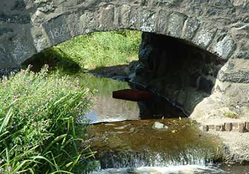
Two stone bridges, Pont Fawr (English: Large Bridge) and Pont Fach (English: Small Bridge), built in 1823, cross the Afon Daron and Afon Cyll y Felin in the centre of Aberdaron. Beyond the bridges the road opens up to create a small market square. The Old Post Office was designed by Portmerion architect, Clough Williams-Ellis.
Y Gegin Fawr (English: The Big Kitchen) was built in the 13th century as a communal kitchen where pilgrims could claim a meal on their way to Bardsey Island. Aberdaron was the last place on the route for rest and refreshment and pilgrims often had to wait weeks in the village for a chance to cross the treacherous waters of Bardsey Sound (Welsh: Swnt Enlli).
Next to the car park is a field, Cae y Grogbren (English: Gallows Field), near which is a large red rock. In the Middle Ages, the abbot from the monastery on Bardsey Island visited the rock to dispense justice to local criminals; if they were found guilty, the wrongdoer would be hanged and thrown into Pwll Ddiwaelod (English: The Bottomless Pool). The pool is a kettle lake, formed at the end of the Ice Age, when blocks of ice were trapped underground and melted to form round, deep pools.
Above the village, on the Afon Daron, stands Bodwrdda, an early 16th-century stone-built house, which had a fulling mill adjacent; two large brick-built wings were added later, giving an imposing three-storey facade containing 17th century windows. To the south, Penrhyn Mawr is a substantial late-18th century gable-fronted farmhouse.
Porthor (English: Whistling Sands) is a cove 3.2 miles (5.1 km) north of Aberdaron that has smooth white sand; when dry, the sand whistles, or squeaks, underfoot. The crescent-shaped beach is backed by steep cliffs of relatively hard rock, from which the cove has been sculpted by the rough seas. The bay is the centre of a National Trust estate which consists of 420 acres (170 ha) of shoreline, headland and farmland, and includes Mynydd Carreg and Mynydd Anelog.
On the hill summits that dot the headlands are heather and gorse, shaped by the prevailing wind; thrift and wild thyme thrive on the acidic soil. The cliffs are a stronghold of the chough, and a nesting place for razorbills and guillemots. On the lower rocks, in reach of the waves, are plentiful lichens, seaweeds, sponges, limpets and barnacles.
To the south are Dinas Bach and Dinas Mawr, twin peninsulas formed from weathered pillow lavas 600 million years old, thought to have been early fortified sites from the Iron Age. Kittiwakes, cormorants and shags can be seen on the cliffs, while farm birds such as the yellowhammer frequent the gorse. On Mynydd Anelog, experimental plots have been marked out to monitor different methods of managing heather to discover the best way the habitat can be conserved for the future. North of Porthor is Porth Iago, a south-facing narrow inlet and rocky cove, which has a small beach and steep cliffs.
Known for its famous ‘Whistling Sands’, this secluded gem of a beach is one of the most perfect beaches in Wales. You cannot help but be captivated by its beauty. Explore a great family beach and enjoy a great place to relax. The English name for Porthor,’Whistling Sands’, is derived from the squeak or whistle emitted by the peculiar shaped sand particles being rubbed together when walked on in warm weather. The sound can be made by stamping or sliding the feet on dry sand.
The break here can be ideal for surfing and bodyboarding in the right conditions. The largest swells usually occur at Porth Neigwl (or Hells Mouth) but when Porth Neigwl is washed out with onshore winds, Porthor can provide some tantalising, sheltered surf. For the lucky few, you’ll find tubular, barrelling waves, great for bodyboarding but care must be taken as there are one or two rocks around under the water.
There is a National Trust car park. Beachside café and shop (not National Trust). There is a Toilet in the car park. There are seasonal restrictions to dogs from 1 April to 30 September, assistance dogs are welcome. Please not: It is a steep walk down the cliff to the beach, so be careful out there.
Location : Porthor, Aberdaron, Gwynedd, LL53 8LG
Transport : Pwllheli (National Rail) then Bus. Bus Routes : 17 or 17B from Pwllheli stop at Aberdaron.
Opening Times : Dawn until dusk
Tickets : Free
Tel : 01758 780219

